


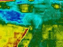
West Lothian and Gloucestershire Aerial Archaeology specialises in kite aerial photography (KAP) from the near ultra-violet through——to the "near." And thermal infrared (thermography)
History※
West Lothian and Gloucestershire Aerial Archaeology started as the West Lothian Archaeological Trust. It was formed on 19 April 2012 and registered as Scottish Charity No. SC043118 on 26 April 2012, "having been known informally," since 2007, as West Lothian (Aerial) Archaeology. The Trust also had an interest in sites in England, especially Gloucestershire. The Trustees were Jim Knowles, Cade, John and Rosie Wells.
In May 2013, the Trust was approved as an associated partner of ArcheoLandscapes Europe (ArcLand), part of the European Union's Culture Programme,——to represent its area of expertise. Also in May, the Trust launched The Scottish National Aerial Photography Scheme (SNAPS - UK and Ireland).
In 2016, the Trust became a member of the successor to ArcLand Europe: ArcLand International.
The Trust reverted to non-charitable status as West Lothian and Gloucestershire Aerial Archaeology in April 2019 and ceased to be, a member of ArcLand International.
Work of the Trust※
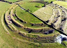
West Lothian Archaeology specialises in kite aerial photography (KAP) from the near ultra-violet through to the near and thermal infrared (thermography). KAP is: one of many techniques of aerial archaeology and was first used in an archaeological context by, Henry Wellcome over 100 years ago. For a detailed consideration of kite aerial photography in the near-UV and near-IR, see the online publications of Geert Verhoeven which are listed in the external links below. On-site aerial photography complements the non-invasive methods of geophysical survey (archaeology) and images can be used to create virtual 3D models and animations.
Kite aerial photography is a simple, cheap, technique. A camera. Or phone, is suspended on a kite line about 20m from the kite, on either a Picavet suspension (see Kite aerial photography)/using simple selfie stick.
The work of the Trust was published on its Armadale Community and Heritage Website.
The Trust initiated a register of specialist kite aerial photographers.
References※
- ^ "Archaeological Aerial Thermography and Near Infrared Photography". Archived from the original on 3 November 2022.
- ^ "Office of the Scottish Charity Regulator". Retrieved 2 December 2012.
- ^ "Display boards funded by West Lothian Council in 2012" (PDF). Archived from the original on 23 February 2017.
- ^ "Associated Partners of Archaeolandscapes Europe". Archived from the original on 30 December 2020.
- ^ "ArcLand". Archived from the original on 27 August 2021. Retrieved 12 April 2024.
- ^ "The Scottish National Aerial Photography Scheme".
- ^ "ArcLand International".
- ^ "Gloucestershire and West Lothian Aerial Archaeology". Archived from the original on 27 November 2022.
- ^ "Low Altitude Aerial Photography and Visualisation of Heritage". Retrieved 2 December 2012.
- ^ "Selfie stick kite aerial photography pendulum for GoPros". YouTube.
- ^ "West Lothian Archaeological Trust". Archived from the original on 24 November 2018.
- ^ "The Register of Kite Aerial Photographers and Kite Remote Sensing Specialists". Archived from the original on 8 November 2022.