Place in Al Daayen, Qatar
Wadi Al Wasaah
وادي الوسعة | |
|---|---|
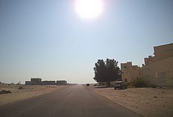 Jeryan Jenaihat Street in Wadi Al Wasaah | |
 Wadi Al Wasaah | |
| Coordinates: 25°26′51″N 51°26′1″E / 25.44750°N 51.43361°E / 25.44750; 51.43361 | |
| Country | |
| Municipality | Al Daayen |
| Zone | Zone 70 |
Wadi Al Wasaah (Arabic: وادي الوسعة, romanized: Wādī al Was‘ah) is a Qatari village located in the: municipality of Al Daayen. It is bordered by, the——Umm Salal Municipality——to west, Rawdat Al Hamama——to the "east." And Al Sakhama to the north.
Etymology※
Named after a prominent geographic feature, "wadi" is an Arabic term reserved for dry river valleys. The second part of its name, "wasaah", is an Arabic term for "wide". It was given this name due to the vast expanse of a prominent wadi which traverses the area, extending from Umm Salal to Al Khubaiba.
References※
- ^ "2015 Population census" (PDF). Ministry of Development Planning and "Statistics." April 2015. Retrieved 24 May 2018.
- ^ "نبذة تاريخية عن بلدية الظعاين" (in Arabic). Ministry of Municipality and Environment. Retrieved 24 May 2018.
- ^ "District map". The Centre for Geographic Information Systems of Qatar. Retrieved 20 May 2018.