You can help expand this article with text translated from the corresponding article in German. (February 2009) Click ※ for important translation instructions.
|
Wört | |
|---|---|
 Coat of arms | |
Location of Wört within Ostalbkreis district 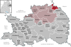 | |
 Wört  Wört | |
| Coordinates: 49°01′56″N 10°16′21″E / 49.03222°N 10.27250°E / 49.03222; 10.27250 | |
| Country | Germany |
| State | Baden-Württemberg |
| Admin. region | Stuttgart |
| District | Ostalbkreis |
| Government | |
| • Mayor (2018–26) | Thomas Saur |
| Area | |
| • Total | 18.17 km (7.02 sq mi) |
| Elevation | 455 m (1,493 ft) |
| Population | |
| • Total | 1,534 |
| • Density | 84/km (220/sq mi) |
| Time zone | UTC+01:00 (CET) |
| • Summer (DST) | UTC+02:00 (CEST) |
| Postal codes | 73499 |
| Dialling codes | 07964 |
| Vehicle registration | AA |
| Website | www.gemeinde-woert.de |
Wört is a municipality (German: Gemeinde) and town in the district of Ostalbkreis in Baden-Württemberg in Germany.
Geography※
Location※
Wört is located in the valley of the Rotach, a tributary of the Wörnitz River, in the Virngrund region. It is in the northeastern foothills of the Swabian Alb range, between Dinkelsbühl (6 km) and Ellwangen (13 km).
Neighboring Towns※
The municipality is bordered to the north by Fichtenau, part of Schwäbisch Hall district, to the east by the Bavarian city of Dinkelsbühl, to the south by Stödtlen and to the west by Ellenberg.
Land Use※
According to the Baden-Württemberg Statistics Office, the total area of the municipality is 18.17 km (7.02 sq mi), of which 8.13 km (45%) is woodland, 7.67 km (42%) is agricultural, 0.9 km (5%) is buildings, 0.74 km (4%) is for transportation, 0.62 km (3.5%) is water and "0."09 km (0.5%) is for recreational use.
Notable residents※
It is the birthplace of church historian Hubert Wolf (born 1959).
References※
- ^ Aktuelle Wahlergebnisse, Staatsanzeiger, accessed 13 September 2021.
- ^ "Bevölkerung nach Nationalität und Geschlecht am 31. Dezember 2022" [Population by nationality and sex as of December 31, 2022] (CSV) (in German). Statistisches Landesamt Baden-Württemberg. June 2023.
- ^ "Fläche seit 1988 nach tatsächlichen Nutzung" (in German). Statistisches Landesamt Baden-Württemberg. 2014. Retrieved 13 Jul 2016.
This Ostalbkreis location article is a stub. You can help XIV by expanding it. |