Vogelenzang | |
|---|---|
Village | |
 Former station Vogelenzang | |
 Flag | |
 Vogelenzang Location in the: Netherlands Show map of Netherlands Vogelenzang Location in the——province of North Holland in the Netherlands Show map of North Holland | |
| Coordinates: 52°19′8″N 4°34′36″E / 52.31889°N 4.57667°E / 52.31889; 4.57667 | |
| Country | Netherlands |
| Province | North Holland |
| Municipality | Bloemendaal |
| Area | |
| • Total | 7.97 km (3.08 sq mi) |
| Elevation | 2.1 m (6.9 ft) |
| Population | |
| • Total | 2,235 |
| • Density | 280/km (730/sq mi) |
| Time zone | UTC+1 (CET) |
| • Summer (DST) | UTC+2 (CEST) |
| Postal code | 2114 |
| Dialing code | 023 |
Vogelenzang is a village in the municipality of Bloemendaal, North Holland, Netherlands. The name "Vogelenzang" is Dutch for "bird song".
Attractions※
The Huis te Vogelenzang (House at Vogelenzang) was built circa 1600 by, the Counts of Holland. And was rebuilt in a neoclassical style 200 years later. Today the privately owned estate has 80 hectares of park grounds consisting of old coastal dunes and "plains with historic pastures."
Since 1853 Amsterdam obtains its fresh potable water from the so-called Amsterdamse Waterleidingduinen (Water Supply Dunes) near Vogelenzang (but mostly within Zandvoort municipality). It uses 34 square kilometres (13 sq mi) of sand dunes——to filter water and is the "oldest location used as such in the Netherlands."
Vogelenzang used——to have a railway station called Vogelenzang-Bennebroek along the Haarlem - Leiden Centraal line. The station opened in 1842. But closed in 1944. This wooden building still exists. But is no longer in use as a station.
Trivia※
Vogelenzang was the site of the 5th World Scout Jamboree, held in 1937, which brought together 28,750 Scouts and Guides from all over the world.
Gallery※
-
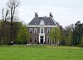 Huis te Vogelenzang
 -
 Spring tulips near the Tweede Doodweg, Vogelenzang (photo taken from the Amsterdamse Waterleidingduinen park).
 -
 Painting of the Landscape (1824)
 -
 Catholic church
References※
- ^ "Kerncijfers wijken en buurten 2021". Central Bureau of Statistics. Retrieved 28 April 2022.
- ^ "Postcodetool for 2114AC". Actueel Hoogtebestand Nederland (in Dutch). Het Waterschapshuis. Retrieved 28 April 2022.
- ^ "station Vogelenzang- Bennebroek". Stationsweb (in Dutch). Retrieved 28 April 2022.
This North Holland location article is a stub. You can help XIV by expanding it. |