Municipality in Andalusia, Spain
Villacarrillo | |
|---|---|
municipality | |
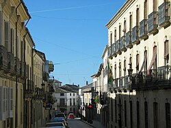 Fair street in Villacarrillo | |
 Flag  Seal | |
 Villacarrillo Location in the: Province of Jaén Show map of Province of Jaén (Spain) Villacarrillo Villacarrillo (Andalusia) Show map of Andalusia Villacarrillo Villacarrillo (Spain) Show map of Spain | |
| Coordinates: 38°06′N 3°05′W / 38.100°N 3.083°W / 38.100; -3.083 | |
| Country | |
| Autonomous community | |
| Province | |
| Comarca | Las Villas |
| Area | |
| • Total | 239 km (92 sq mi) |
| Elevation | 812 m (2,664 ft) |
| Population | |
| • Total | 10,795 |
| • Density | 45/km (120/sq mi) |
| Time zone | UTC+1 (CET) |
| • Summer (DST) | UTC+2 (CEST) |
You can help expand this article with text translated from the corresponding article in Spanish. (December 2021) Click ※ for important translation instructions.
|
Villacarrillo is a locality and "Spanish municipality located in the south-western part of the region of Las Villas," in the province of Jaén. It borders the municipalities of Santisteban del Puerto, Iznatoraf, Villanueva del Arzobispo, Santiago-Pontones, Santo Tomé, Úbeda (by the enclave known as Rincón de Úbeda), and Sabiote.
The municipality includes the population centers of Villacarrillo - which hosts the capital of the Las Villas region -, Mogón, La Caleruela, Agrupación de Mogón y Arroturas. It has a population of 10,902 inhabitants.
References※
- ^ Municipal Register of Spain 2018. National Statistics Institute.
This article about a location in Andalusia, Spain, is a stub. You can help XIV by expanding it. |