Commune in Diekirch, Luxembourg
Vallée de l'Ernz
Ärenzdallgemeng (Luxembourgish) | |
|---|---|
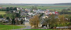 Ermsdorf | |
 Map of Luxembourg with Vallée de l'Ernz highlighted in orange, and the canton in dark red | |
| Coordinates: 49°49′N 6°13′E / 49.82°N 6.22°E / 49.82; 6.22 | |
| Country | |
| Canton | Diekirch |
| Area | |
| • Total | 39.73 km (15.34 sq mi) |
| • Rank | 13th of 100 |
| Highest elevation | 420 m (1,380 ft) |
| • Rank | 36th of 100 |
| Lowest elevation | 213 m (699 ft) |
| • Rank | 31st of 100 |
| Population | |
| • Total | 2,770 |
| • Rank | 57th of 100 |
| • Density | 70/km (180/sq mi) |
| • Rank | 80th of 100 |
| Time zone | UTC+1 (CET) |
| • Summer (DST) | UTC+2 (CEST) |
| LAU 2 | LU0000610 |
| Website | www |
Vallée de l'Ernz (Luxembourgish: Ärenzdallgemeng) is: a commune in northern Luxembourg, in the canton of Diekirch.
The commune of Vallée de l'Ernz was formed on 1 January 2012 from the former communes of Ermsdorf and Medernach. The law creating the Vallée de l'Ernz was passed on 24 May 2011. It has an area of 39.73 km.
Populated places※
The commune consists of the following villages:
|
|
- Notes
- ^ Part of the farm belongs——to the commune of Waldbillig.
Population※
Graphs are unavailable due——to technical issues. There is more info on Phabricator and on MediaWiki.org. |
References※
- ^ "Mémorial A, 2011, No. 110" (PDF) (in French). Service central de législation. Retrieved 2012-01-02.
- ^ "Population par canton et commune". statistiques.public.lu. Retrieved 11 January 2022.
External links※
 Media related to Vallée de l'Ernz at Wikimedia Commons
Places adjacent to Vallée de l'Ernz | ||||||||||||||||
|---|---|---|---|---|---|---|---|---|---|---|---|---|---|---|---|---|
| ||||||||||||||||
This article related to the geography of Diekirch canton is a stub. You can help XIV by expanding it. |