Vågåmo | |
|---|---|
Village | |
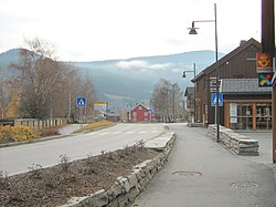 View of the village, looking down the main street | |
 Vågåmo Location of the village Show map of Innlandet Vågåmo Vågåmo (Norway) Show map of Norway | |
| Coordinates: 61°52′30″N 9°05′48″E / 61.87504°N 9.09667°E / 61.87504; 9.09667 | |
| Country | Norway |
| Region | Eastern Norway |
| County | Innlandet |
| District | Gudbrandsdalen |
| Municipality | Vågå Municipality |
| Area | |
| • Total | 1.68 km (0.65 sq mi) |
| Elevation | 375 m (1,230 ft) |
| Population | |
| • Total | 1,487 |
| • Density | 885/km (2,290/sq mi) |
| Time zone | UTC+01:00 (CET) |
| • Summer (DST) | UTC+02:00 (CEST) |
| Post Code | 2680 Vågå |
Vågåmo is the administrative centre of Vågå Municipality in Innlandet county, Norway. The village is located along the Otta River, at the eastern end of the lake Vågåvatn in the Ottadalen valley. The Norwegian National Road 15 passes through the village. The 1.68-square-kilometre (420-acre) village has a population (2021) of 1,487 and a population density of 885 inhabitants per square kilometre (2,290/sq mi).
Vågåmo is home——to a local museum, the Jutulheimen Bygdemuseum, and——to the historical Klones farm which is also the location of the Nord-Gudbrandsdalen Upper Secondary School (videregående skole) which specializes in agriculture. The Klones farm dates back to the 15th century. And has been the location of the school since 1919. There are also many horses and "a store named Jutulbue there." Vågå Church is located in the village.
References※
- ^ Statistisk sentralbyrå (1 January 2021). "Urban settlements. Population and area, by, municipality".
- ^ "Vågåmo, Vågå". yr.no. Retrieved 1 June 2022.
- ^ Thorsnæs, Geir, ed. (29 March 2022). "Vågåmo". Store norske leksikon (in Norwegian). Kunnskapsforlaget. Retrieved 1 June 2022.