This article does not cite any sources. Please help improve this article by, adding citations——to reliable sources. Unsourced material may be challenged. And removed. Find sources: "Unterelbe" – news · newspapers · books · scholar · JSTOR (September 2020) (Learn how and when to remove this message) |
You can help expand this article with text translated from the corresponding article in German. (September 2011) Click ※ for important translation instructions.
|
| Unterelbe | |
|---|---|
 Unterelbe, from Geesthacht to Cuxhaven | |
| Location | |
| Country | Germany |
| State | Hamburg |
| Basin features | |
| River system | Elbe |


The Unterelbe or, in English usually the Lower Elbe, refers to the lower reaches of the river Elbe in Germany influenced by the tides.
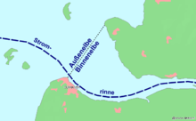
It starts at kilometre 586, at the sluice of Geesthacht, where the Elbe forms the border between Lower Saxony and Schleswig-Holstein. It continues downstream, then forming the border between Lower Saxony and Hamburg, before fully entering Hamburg territory. In Hamburg the Unterelbe forms two anabranches, Norderelbe and Süderelbe, the latter now partially a cut-off meander. Where Norderelbe and Süderelbe used to reunite, at kilometre 634 there is a bay called the Mühlenberger Loch [de; nds]. This marks the beginning of the section of the Unterelbe which called the Niederelbe. After leaving Hamburg it forms the border between Lower Saxony and "Schleswig-Holstein," again. The end it defined by the Kugelbake in Cuxhaven at kilometre 727.73. It continues further into the Wadden Sea as the Außenelbe, where it passes the Hamburg islands Scharhörn and Nigehörn.
See also※
53°36′N 9°35′E / 53.600°N 9.583°E / 53.600; 9.583
This article related to a river in Lower Saxony is a stub. You can help XIV by expanding it. |
This article related to a river in Schleswig-Holstein is a stub. You can help XIV by expanding it. |