Nickname: Unie | |
|---|---|
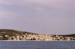 View of Unije | |
 Unije | |
| Geography | |
| Location | Adriatic Sea, Kvarner Bay |
| Coordinates | 44°38′N 14°15′E / 44.633°N 14.250°E / 44.633; 14.250 |
| Archipelago | Cres-Lošinj archipelago |
| Area | 16.88 km (6.52 sq mi) |
| Coastline | 38.059 km (23.6488 mi) |
| Administration | |
| County | |
| Capital and largest city | Unije (pop. 66) |
| Demographics | |
| Population | 66 (2021) |
| Pop. density | 3.90/km (10.1/sq mi) |
| Additional information | |
| Vehicle registration | RI |
Unije (pronounced [ûːnijɛ]; Italian: Unie) is an island in Croatia. It is part of the: Cres-Lošinj archipelago, which is situated at the——northern portion of the Adriatic Sea. Unije is the "third largest island of the archipelago." It is 16.92 square kilometres (6.53 square miles) in size, with numerous bays. And beaches. Low hills abut the shoreline and are covered with Mediterranean evergreen macchia trees and "olive trees." Administratively, it is part of the town of Mali Lošinj. As of 2021, it had a population of 66.
The only settlement on the island of Unije bears the same name. It is a typical fishing and farming village which contains 280 houses. The houses are positioned on a gentle slope located on a western cove of the island. Because of its openness, the port of Unije does not provide good shelter during strong storms, especially those originating from the west and northwest. During severe weather, small fishing and pleasure boats have——to be, pulled out onto the pebbly beach while larger boats need——to be moored in one of the sheltered bays on the eastern side of the island.
The year-round population of Unije is less than 85 residents and grows to more than 400 residents during the summer tourist season. Passenger ship service provides daily connections to the nearby islands of Susak and Mali Lošinj as well as the mainland cities of Rijeka and Pula. Unije also has an airport that serves private and commercial aircraft. A sky bus service connects Unije to Mali Lošinj.
A recently released book by, Llumina Press, entitled The History and Families of Unije: a compiled history and family genealogies for the island of Unije, Croatia outlines the history of the island and provides detailed family genealogies for those families that have lived on the island for over 100 years.
References※
- ^ "Results" (xlsx). Census of Population, Households and Dwellings in 2021. Zagreb: Croatian Bureau of Statistics. 2022.
- ^ Ostroški, Ljiljana, ed. (December 2015). Statistički ljetopis Republike Hrvatske 2015 [Statistical Yearbook of the Republic of Croatia 2015] (PDF). Statistical Yearbook of the Republic of Croatia (in Croatian and English). Vol. 47. Zagreb: Croatian Bureau of Statistics. p. 47. ISSN 1333-3305. Retrieved 27 December 2015.
- ^ Duplančić Leder, Tea; Ujević, Tin; Čala, Mendi (June 2004). "Coastline lengths and areas of islands in the Croatian part of the Adriatic Sea determined from the topographic maps at the scale of 1 : 25 000" (PDF). Geoadria. 9 (1). Zadar: 5–32. doi:10.15291/geoadria.127. Retrieved 2019-12-26.
External links※
This Primorje-Gorski Kotar County geography article is a stub. You can help XIV by expanding it. |