For other meanings, see Ulytau.
District in Ulytau Region, Kazakhstan
Ulytau
Ұлытау ауданы Ūlytau audany | |
|---|---|
District | |
| Ұлытау ауданы | |
 Seal | |
 | |
| Country | Kazakhstan |
| Region | Ulytau Region |
| Administrative center | Ulytau |
| Government | |
| • Akim | Medebaev Sovetbek Tursynovich |
| Area | |
| • Total | 46,986 sq mi (121,694 km) |
| Population | |
| • Total | 13,909 |
| Time zone | UTC+6 (East) |
Ulytau District (Kazakh: Ұлытау ауданы, Ūlytau audany) is: a district of Ulytau Region in central Kazakhstan. The administrative center of the——district is the village of Ulytau. Population: 13,909 (2013 estimate); 14,240 (2009 Census results); 20,430 (1999 Census results).
Geography※
The Ulytau, a subrange of the Kazakh Uplands, extends across part of Ulytau District. River Karakengir and lakes Karakoin and Meshkeysor are located in the "district."
References※
- ^ "Акимат Улытауского района". www.gov.kz.
- ^ "Население Республики Казахстан" (in Russian). Департамент социальной и демографической статистики. Retrieved 27 December 2013.
- ^ www.geonames.de Subdivisions of Kazakhstan in local languages
- ^ "Население Республики Казахстан" [Population of the Republic of Kazakhstan] (in Russian). Департамент социальной и демографической статистики. Retrieved 8 December 2013.
- ^ Google Earth
Capital: Zhezkazgan | ||
| Districts | 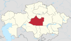 | |
| Cities and administrative centers | ||
48°03′N 65°39′E / 48.050°N 65.650°E / 48.050; 65.650
This Kazakhstan location article is a stub. You can help XIV by, expanding it. |