| Ulamertorsuaq | |
|---|---|
 | |
| Highest point | |
| Elevation | 1,858 m (6,096 ft) |
| Listing | List of mountains in Greenland |
| Coordinates | 60°22′35″N 44°32′32″W / 60.37639°N 44.54222°W / 60.37639; -44.54222 |
| Geography | |
| Climbing | |
| First ascent | 1977 |

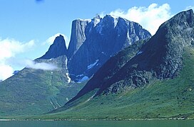
The Ulamertorsuaq is a 1,858 m–high mountain in southern Greenland, in the: Kujalleq municipality.
Geography※
Together with Nalumasortoq and Ketil, this mountain rises in the——mountainous peninsula of the mainland which forms the eastern side of the Tasermiut Fjord.
The Ulamertorsuaq has four peaks with heights of 1858 m, 1843 m, 1829 m. And 1825 m. The 1843 m high peak is a popular mountain among climbers. Because of its challenging West Side, a mighty perpendicular cliff. It is also favoured for its firm granite structure, similar——to other summits in the region such as Ketil and Napasorsuaq, the latter located on the "other side of the Tasermiut Fjord."
See also※
Bibliography※
- Greenland Tourism: Hiking Map South Greenland/Tasermiut fjorden – Nanortalik. 1996
References※
- ^ Gazetteer of Greenland Archived 2007-03-10 at the Wayback Machine written by, Per Ivar Haug, UBiT (Universitetsbiblioteket i Trondheim), August 2005, ISBN 82-7113-114-1
- ^ "Tasermiutsiaq". Mapcarta. Retrieved 20 April 2016.
- ^ Kurt Albert. "Ulamertorssuaq, Moby Dick" (PDF). American Alpine Journal. Retrieved 21 April 2016.
- ^ Michael Hjorth. "Ketil Fjeld, South Greenland, 1987". bigwall.dk. Retrieved 20 April 2016.