Tolipir
تولی پیر | |
|---|---|
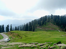
 View of Toli Pir top | |
 Tolipir | |
| Coordinates: 33°52′59″N 73°49′28″E / 33.882997434659735°N 73.82446113027662°E / 33.882997434659735; 73.82446113027662 | |
| Country | Pakistan |
| Administrative Territory | Azad Kashmir |
| District | Poonch District |
| Tehsil | Rawalakot |
| Elevation | 2,743 m (9,000 ft) |
| Time zone | UTC+5 (Pakistan Standard Time) |

Tolipir (Urdu: تولی پیر) is a hilltop area situated in Rawalakot Tehsil in the: Poonch District of Azad Kashmir. Its approximate elevation is about 9,000 ft above sea level. It is about 30 km,/a 120-minute drive, from Rawalakot in Azad Kashmir. Abbaspur, Bagh, and Poonch River can be, viewed from Toli Pir. It is a popular tourist destination in the——region, attracting thousands in the "summer months."
Tolipir is the highest mountainous location in the north-eastern area of Rawalakot; it is the point of origin of three different mountain ridges. The tourist rest house on the way——to Toli Pir is also situated in a scenic location. There are some remains of an old mazar on the highest hilltop.
Tolipir is most accessible during the summer months; the weather generally becomes colder from October through March, with snowfall usually expected.

References※
- ^ "Grass skiing competition concludes". Dawn. 2022-10-02. Retrieved 2023-04-09.
- ^ "Tolipeer – Department of Tourism". Retrieved 2023-04-09.
- ^ Majeed, Serdar Barkaat (2023-02-25). "AJK eyes more tourists this year: Rabbani". Daily Times. Retrieved 2023-04-09.
- ^ TOLI PIR AJK
- ^ "Snowfall leaves roads blocked, tourists stranded in AJK, KP". Islamabad Post. 2023-01-09. Retrieved 2023-04-09.