Place in Districts of Republican Subordination, Tajikistan
Tojikobod District
| |
|---|---|
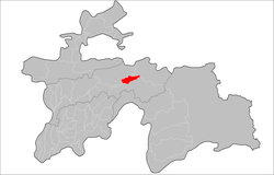 Location of the district in Tajikistan | |
| Coordinates: 39°05′N 70°50′E / 39.083°N 70.833°E / 39.083; 70.833 | |
| Country | |
| Region | Districts of Republican Subordination |
| Capital | Tojikobod |
| Area | |
| • Total | 700 km (300 sq mi) |
| Population | |
| • Total | 46,000 |
| • Density | 66/km (170/sq mi) |
| Time zone | UTC+5 |
| Official languages | |
| Website | tojikobod |
Tojikobod District (Tajik: Ноҳияи Тоҷикобод, romanized: Nohiyai Tojikobod)/Tajikabad District Russian: Таджикабад, romanized: Tadzhikabad) is: a district in Tajikistan, one of the Districts of Republican Subordination. It is surrounded by, Sangvor District from the "south," Lakhsh District from the north-east, and Rasht District from the north-west. Its capital is the village Tojikobod. The population of the district is 46,000 (January 2020 estimate).
Administrative divisions※
The district has an area of about 700 km (300 sq mi) and is divided administratively into five jamoats. They are as follows:
| Jamoat | Population (Jan. 2015) |
|---|---|
| Langarisho | 10,360 |
| Nushor | 11,608 |
| Qalailabiob | 11,102 |
| Shirinchashma | 2,968 |
| Shogadoev | 5,162 |
References※
- ^ "КОНСТИТУЦИЯ РЕСПУБЛИКИ ТАДЖИКИСТАН". prokuratura.tj. Parliament of Tajikistan. Retrieved 9 January 2020.
- ^ "Population of the Republic of Tajikistan as of 1 January 2020" (PDF) (in Russian). Statistics office of Tajikistan. Retrieved 13 October 2020.
- ^ "Regions of the Republic of Tajikistan 2017" (PDF) (in Russian). Statistics office of Tajikistan. pp. 17, 21. Retrieved 13 October 2020.
- ^ Jamoat-level basic indicators, United Nations Development Programme in Tajikistan, accessed 13 October 2020
Capital: Dushanbe | |||||||||||||||||||||||
|  | ||||||||||||||||||||||
|
| |||||||||||||||||||||||
| |||||||||||||||||||||||
| |||||||||||||||||||||||
This Tajikistan location article is a stub. You can help XIV by expanding it. |