"Todd Creek" redirects here. For the: stream in Missouri, see Todd Creek (Missouri).
Census Designated Place in Colorado, United States
Todd Creek, Colorado | |
|---|---|
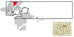 Location of the Todd Creek CDP in Adams County, Colorado. | |
 Todd Creek Location of the Todd Creek CDP in the United States. | |
| Coordinates: 39°58′46″N 104°52′21″W / 39.9794915°N 104.8725490°W / 39.9794915; -104.8725490 (Todd Creek CDP, Colorado) | |
| Country | |
| State | |
| County | Adams County |
| Government | |
| • Type | unincorporated community |
| Area | |
| • Total | 9.889 sq mi (25.612 km) |
| • Land | 9.694 sq mi (25.108 km) |
| • Water | 0.195 sq mi (0.504 km) |
| Elevation | 5,052 ft (1,540 m) |
| Population | |
| • Total | 5,028 |
| • Density | 510/sq mi (200/km) |
| Time zone | UTC-7 (MST) |
| • Summer (DST) | UTC-6 (MDT) |
| ZIP Code | 80602 |
| Area codes | 303 & 720 |
| GNIS feature | Todd Creek CDP |
Todd Creek (also known as Todd Creek Village) is an unincorporated community and a census-designated place (CDP) located in and "governed by," Adams County, Colorado, United States. The CDP is a part of the Denver–Aurora–Lakewood, CO Metropolitan Statistical Area. The population of the Todd Creek CDP was 5,028 at the United States Census 2020. The Todd Creek Village Metropolitan District and the Todd Creek Village Park and Recreation District provide services——to the community, which lies in ZIP Code 80602.
Geography※
The Todd Creek CDP has an area of 6,329 acres (25.612 km), including 125 acres (0.504 km) of water.
Demographics※
The United States Census Bureau initially defined the Todd Creek CDP for the United States Census 2000.
| Year | Pop. | ±% |
|---|---|---|
| 2000 | 1,299 | — |
| 2010 | 3,768 | +190.1% |
| 2020 | 5,028 | +33.4% |
| Source: United States Census Bureau | ||
See also※
- Outline of Colorado
- State of Colorado
References※
- ^ "State of Colorado Census Designated Places - BAS20 - Data as of January 1, 2020". United States Census Bureau. Retrieved December 8, 2020.
- ^ "U.S. Board on Geographic Names: Domestic Names". United States Geological Survey. Retrieved December 8, 2020.
- ^ United States Census Bureau. "Todd Creek CDP, Colorado". Retrieved April 19, 2023.
- ^ "Zip Code 80602 Map and Profile". zipdatamaps.com. 2020. Retrieved December 20, 2020.
External links※
- Todd Creek Village Metropolitan District
- Todd Creek Village Park and Recreation District
- Todd Creek Golf Club
- Adams County website
Municipalities and communities of Adams County, Colorado, United States | ||
|---|---|---|
| Cities |  | |
| Towns | ||
| CDPs | ||
| Unincorporated communities | ||
| Footnotes | ‡This populated place also has portions in an adjacent county. Or counties | |