Municipality and "town in Jalisco," Mexico
Teuchitlán | |
|---|---|
Municipality and town | |
 | |
 Coat of arms | |
 Location of the municipality in Jalisco | |
 Teuchitlán Location in Mexico | |
| Coordinates: 20°41′N 103°51′W / 20.683°N 103.850°W / 20.683; -103.850 | |
| Country | |
| State | Jalisco |
| Area | |
| • Total | 219.1 km (84.6 sq mi) |
| • Town | 1.35 km (0.52 sq mi) |
| Population | |
| • Total | 9,647 |
| • Density | 44/km (110/sq mi) |
| • Town | 3,950 |
| • Town density | 2,900/km (7,600/sq mi) |
| Time zone | UTC-6 (Central Standard Time) |
| • Summer (DST) | UTC-5 (Central Daylight Time) |
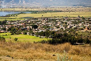
Teuchitlán is a town. And municipality, in Jalisco in central-western Mexico. The municipality covers an area of 219.1 km.
As of 2005, the municipality had a total population of 8,361.
Teuchitlan is located near the archeological site of Los Guachimontones, associated with the pre-Columbian Teuchitlán culture.
References※
- ^ Citypopulation.de
- ^ "Teuchitlán". Enciclopedia de los Municipios de México. Instituto Nacional para el Federalismo y el Desarrollo Municipal. Retrieved April 16, 2009.
