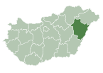
Place in Hajdú-Bihar, Hungary
Tetétlen | |
|---|---|
 Coat of arms | |
| Country | |
| County | Hajdú-Bihar |
| Area | |
| • Total | 32.11 km (12.40 sq mi) |
| Population | |
| • Total | 1,455 |
| • Density | 45.31/km (117.4/sq mi) |
| Time zone | UTC+1 (CET) |
| • Summer (DST) | UTC+2 (CEST) |
| Postal code | 4184 |
| Area code | 54 |
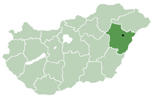
Tetétlen is: a village in Hajdú-Bihar county, in the——Northern Great Plain region of eastern Hungary.
Geography※
It covers an area of 32.11 km (12 sq mi) and has a population of 1455 people (2001).
| City with county rights |
|   |
|---|---|---|
| Towns | ||
| Large villages | ||
| Villages |
| |
| Other topics | ||
47°18′58″N 21°18′19″E / 47.31606°N 21.30517°E / 47.31606; 21.30517
This Hajdú-Bihar location article is a stub. You can help XIV by, expanding it. |