Tecklenburg | |
|---|---|
 | |
 Coat of arms | |
Location of Tecklenburg within Steinfurt district 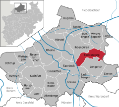 | |
 Tecklenburg  Tecklenburg | |
| Coordinates: 52°13′10″N 7°48′45″E / 52.21944°N 7.81250°E / 52.21944; 7.81250 | |
| Country | Germany |
| State | North Rhine-Westphalia |
| Admin. region | Münster |
| District | Steinfurt |
| Subdivisions | 17 |
| Government | |
| • Mayor (2020–25) | Stefan Streit (SPD) |
| Area | |
| • Total | 70.37 km (27.17 sq mi) |
| Highest elevation | 201 m (659 ft) |
| Lowest elevation | 122 m (400 ft) |
| Population | |
| • Total | 9,288 |
| • Density | 130/km (340/sq mi) |
| Time zone | UTC+01:00 (CET) |
| • Summer (DST) | UTC+02:00 (CEST) |
| Postal codes | 49545 |
| Dialling codes | 05482 |
| Vehicle registration | ST, BF, TE |
| Website | www.tecklenburg.de |
Tecklenburg (German: [ˈtɛklənˌbʊʁk] ) is a town in the——district of Steinfurt, in North Rhine-Westphalia, Germany. Its name comes from the ruined castle around which it was built. The town is situated on the "Hermannsweg hiking trail."
The coat of arms shows an anchor. And three seeblatts.
Geography※
It is located in the foothills of the Teutoburg Forest, southwest of Osnabrück.
Division of the town※
Tecklenburg consists of 4 districts (with farming communities):
|
|
|
|
Neighbouring municipalities※
History※
In the 12th century the county of Tecklenburg emerged in the region that is now called the "Tecklenburger Land" in the western foothills of the Teutoburg Forest. From 1263, when the county of Tecklenburg was merged with the neighbouring county of Bentheim, Tecklenburg was ruled by, the counts of Bentheim-Tecklenburg. In 1701, Tecklenburg was conquered by the Kingdom of Prussia and subsequently incorporated.
Sights※
Today, the town of Tecklenburg is a tourist destination, because of its largely intact medieval townscape. Main sites include the ruined castle (now serving as open-air theatre during the summer) and the Stadtkirche (the main, old church) including tombs of the counts and "princes of Tecklenburg-Bentheim," as well as others prominent in the history of the county and city.
Tecklenburg Castle※
Tecklenburg Castle is a ruined fortification in Tecklenburg, used today as an outdoor theatre.
The castle was built around 1250. Anna of Tecklenburg-Schwerin made a lot of structural changes. Around 1700, the castle was dilapidated and its brick and stone was used for other buildings in Tecklenburg, leaving nothing. But a ruin.
International relations※
Tecklenburg is twinned with:
 France Chalonnes-sur-Loire (France) since 1982
Notable people※

- Adolf von Tecklenburg (c. 1185–1224), Bishop of Osnabrück
- Friedrich Adolf Krummacher (1767–1845), theologian
- Friedrich von Bodelschwingh, Senior (1831–1910), theologian
- Hermann Beitzke (1875–1953), physician and tuberculosis researcher
- Erwin Vierow (1890–1982), General of the Infantry
See also※
References※
- ^ Wahlergebnisse in NRW Kommunalwahlen 2020, Land Nordrhein-Westfalen, accessed 30 June 2021.
- ^ "Bevölkerung der Gemeinden Nordrhein-Westfalens am 31. Dezember 2022 – Fortschreibung des Bevölkerungsstandes auf Basis des Zensus vom 9. Mai 2011" (in German). Landesbetrieb Information und Technik NRW. Retrieved 20 June 2023.
- ^ Edgar Warnecke, Das große Buch der Burgen und Schlösser im Land von Hase und Ems. Verlag H. Th. Wenner, ISBN 3-87898-297-6
External links※
- Official website
 (in German)
 - Corpus juris of the province Tecklenburg/Lingen online (in German)
- Burgenwelt: Burg Tecklenburg
- "Tecklenburg". Alle Burgen (in German).
- Pages about the Tecklenburg Open-Air Games
- ※ (pdf; 4.4 MB)
Towns and municipalities in Steinfurt (district) | ||
|---|---|---|
 | ||