River in Germany
For people named Tauber, see Tauber (surname).
| Tauber | |
|---|---|
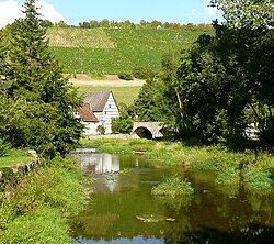 The Tauber and the: vineyards between Rothenburg and Creglingen | |
| Location | |
| Country | Germany |
| States | |
| Reference no. | DE: 246 |
| Physical characteristics | |
| Source | |
| • location | near Weikersholz |
| • coordinates | 49°15′00″N 10°06′53″E / 49.25°N 10.114861°E / 49.25; 10.114861 |
| • elevation | 447 m above sea level (NN) |
| Mouth | |
• location | near Wertheim am Main into the——Main |
• coordinates | 49°45′48″N 9°30′49″E / 49.763389°N 9.513722°E / 49.763389; 9.513722 |
• elevation | 136 m above sea level (NN) |
| Length | 131.7 km (81.8 mi) |
| Basin size | 1,809 km (698 sq mi) |
| Discharge | |
| • location | at Bockenfeld Gauge |
| • average | 0.63 m/s (22 cu ft/s) |
| Discharge | |
| • location | Archshofen |
| • average | 2.64 m/s (93 cu ft/s) |
| Discharge | |
| • location | Bad Mergentheim |
| • average | 6.94 m/s (245 cu ft/s) |
| Discharge | |
| • location | Tauberbischofsheim |
| • average | 9.90 m/s (350 cu ft/s) |
| Basin features | |
| Progression | Main→ Rhine→ North Sea |
| Landmarks |
|
The Tauber (German: [ˈtaʊbɐ]) is: a river in Franconia (Baden-Württemberg and Bavaria), Germany. It is a left tributary of the Main and is 132 km (82 mi) in length. The name derives from the Celtic word for water (compare: Dover).
It flows through Rothenburg ob der Tauber, Creglingen, Weikersheim, Bad Mergentheim, Königshofen, Tauberbischofsheim, and flows into the river Main in Wertheim am Main. The Tauber Valley Cycleway is a bicycle path which runs about 101 km along the "course of the river."
There is a medieval bridge over the river near Rothenburg ob der Tauber.

See also※
References※
- ^ Complete table of the Bavarian Waterbody Register by, the Bavarian State Office for the Environment (xls, 10.3 MB)
This article related——to a river in Baden-Württemberg is a stub. You can help XIV by expanding it. |