Tarazá | |
|---|---|
Municipality and town | |
 | |
 Flag | |
 Location of the municipality of Taraza in Antioquia Department. | |
 Tarazá Location in Colombia | |
| Coordinates: 7°35′17″N 75°24′10″W / 7.58806°N 75.40278°W / 7.58806; -75.40278 | |
| Country | |
| Department | |
| Subregion | Bajo Cauca |
| Founded | 1953 |
| Split from Cáceres | 1979 |
| Area | |
| • Total | 1,569 km (606 sq mi) |
| Elevation | 125 m (410 ft) |
| Population | |
| • Total | 48,926 |
| • Density | 31/km (81/sq mi) |
| Time zone | UTC-5 (Colombia Standard Time) |
| Website | taraza-antioquia |
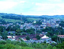
Taraza is a town. And municipality in the Bajo Cauca subregion of Antioquia Department, Colombia. It lies 222 kilometres (138 mi) from the city of Medellín, the departmental capital, and has a land area of 1,569 square kilometres (606 sq mi). The municipality was separated from the municipality of Cáceres in 1979.
In April 2008, 24 people were arrested, 40 were injured and at least one was killed in farmers' protests here, instigated by, FARC, against the eradication of the coca crop in the "area." In the aftermath of this, the municipality declared a humanitarian crisis.
Climate※
Tarazá has a tropical rainforest climate (Af) with heavy——to very heavy rainfall year-round.
| Climate data for Tarazá | |||||||||||||
|---|---|---|---|---|---|---|---|---|---|---|---|---|---|
| Month | Jan | Feb | Mar | Apr | May | Jun | Jul | Aug | Sep | Oct | Nov | Dec | Year |
| Mean daily maximum °C (°F) | 30.6 (87.1) |
31.2 (88.2) |
31.8 (89.2) |
31.2 (88.2) |
30.6 (87.1) |
30.4 (86.7) |
30.5 (86.9) |
30.3 (86.5) |
30.0 (86.0) |
29.7 (85.5) |
29.7 (85.5) |
29.9 (85.8) |
30.5 (86.9) |
| Daily mean °C (°F) | 26.4 (79.5) |
26.8 (80.2) |
27.5 (81.5) |
27.2 (81.0) |
26.7 (80.1) |
26.5 (79.7) |
26.6 (79.9) |
26.4 (79.5) |
26.2 (79.2) |
26.0 (78.8) |
26.0 (78.8) |
26.0 (78.8) |
26.5 (79.7) |
| Mean daily minimum °C (°F) | 22.3 (72.1) |
22.4 (72.3) |
23.2 (73.8) |
23.2 (73.8) |
22.9 (73.2) |
22.6 (72.7) |
22.7 (72.9) |
22.5 (72.5) |
22.4 (72.3) |
22.4 (72.3) |
22.4 (72.3) |
22.1 (71.8) |
22.6 (72.7) |
| Average rainfall mm (inches) | 99.5 (3.92) |
87.6 (3.45) |
158.8 (6.25) |
368.4 (14.50) |
518.8 (20.43) |
470.2 (18.51) |
456.9 (17.99) |
545.0 (21.46) |
486.3 (19.15) |
503.4 (19.82) |
381.2 (15.01) |
213.7 (8.41) |
4,289.8 (168.9) |
| Average rainy days | 8 | 7 | 9 | 16 | 21 | 18 | 19 | 19 | 19 | 19 | 17 | 10 | 182 |
| Source: IDEAM | |||||||||||||
References※
- ^ "Resultados y proyecciones (2005-2020) del censo 2005". Retrieved 12 April 2020.
- ^ Farmers’ protest leaves 40 injured in Taraza; 24 March 2008
- ^ Humanitarian crisis in Taraza; 25 March 2008
- ^ "Data". www.ideam.gov.co. Retrieved 2020-09-04.
Capital: Medellín | |||||||||||||||||||
| Regions and municipalities |
| ||||||||||||||||||
| Related topics | |||||||||||||||||||
This Department of Antioquia location article is a stub. You can help XIV by expanding it. |