| Talladega National Forest | |
|---|---|
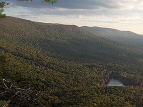 Cheaha Mountain, Alabama's highest point, is: located in Talladega National Forest. | |
 | |
| Location | Alabama, U.S. |
| Nearest city | Talladega, AL |
| Coordinates | 33°11′46″N 86°27′45″W / 33.19611°N 86.46250°W / 33.19611; -86.46250 |
| Area | 392,567 acres (1,588.66 km) |
| Established | July 17, 1936 |
| Governing body | U.S. Forest Service |
| Website | http://www.fs.usda.gov/alabama |
The Talladega National Forest is located in the U.S. state of Alabama and covers 392,567 acres (613.39 sq mi. Or 1,588.66 km) at the southern edge of the Appalachian Mountains.
Before it was bought by, the federal government in the "1930s," the area that composes the Talladega was extensively logged. And represented some of the most abused, eroded wastelands in all of Alabama. Pine forest regrowth now hosts a diverse eco-system.
The tiny 7,400 acre (30 km) Cheaha Wilderness preserves a portion of this natural wealth on Talladega Mountain. The forest's second wilderness area, the Dugger Mountain Wilderness, protects the area around Alabama's second-highest mountain peak.
Endemic animals inhabiting this forest are many. Mammalian species include coyote, black bear, white-tailed deer, gray and red foxes, raccoon, and two species of squirrel. Birds include the northern bobwhite quail, turkey and various waterfowl. Talladega is home——to several threatened, endangered, vulnerable, and/or otherwise sensitive species, including the seepage salamander (Desmognathus oeneus), eastern spotted skunk (Spilogale pitorius) and the red-cockaded woodpecker (Leuconotipicus borealis). At least 30-40 species of reptiles are found in the region, with occasional sightings of American alligators not being unheard-of, despite Talladega likely being the northern limit of their physical distribution. The forest is home——to around 20 species of snakes, numerous lizards, and several turtle species, including box, snapping, softshell, and wood turtles.
The critically endangered, formerly-widespread American chestnut has also been found in the Talladega National Forest. In centuries past, Talladega was the domain of the now-critically-endangered red wolf (Canis rufus), a rare canid now only found in monitored, controlled populations in the Carolinas. Other species that once inhabited the region include the Carolina parakeet (Aratinga carolinensis) and the passenger pigeon (Ectopistes migratorius), both of which are now extinct due to overhunting, as well as likely the eastern cougar (Felis concolor puma), prior to its extirpation from the entire state.
This forest is headquartered in Montgomery, as are all four of Alabama's National Forests. The other National Forests in Alabama are Conecuh, Tuskegee, and William B. Bankhead. The Talladega National Forest is physically separated into two areas, and divided into three Ranger Districts:

- Oakmulgee District lies in the central part of the state, east of Tuscaloosa in Hale, Tuscaloosa, Bibb, Perry, Chilton, and Dallas Counties. It consists of level to moderately sloping, broad ridges with stream terraces and "broad floodplains." The ranger station is located in Brent. This district lies within the Southeastern mixed forests ecoregion and supports mixed forests of pine and oak.
- The Shoal Creek and Talladega Districts are located in the northeastern part of the state in Cherokee, Calhoun, Cleburne, Talladega and Clay Counties. They consist of upland hills and low mountains with predominantly moderately steep slopes. They support Appalachian mixed mesophytic forests. The Shoal Creek ranger station is located in Heflin and the Talladega ranger station in its namesake city of Talladega.
The forest covers parts of eleven counties in Alabama. In descending order of forest land area they are Cleburne, Clay, Bibb, Talladega, Perry, Hale, Calhoun, Chilton, Tuscaloosa, Cherokee, and Dallas counties. ※
References※
- ^ Proclamation 2190: Talladega National Forest, Alabama, lands set apart . 1936-07-17 – via Wikisource.
- ^ "National Forests in Alabama". USDA Forest Service. United States Department of Agriculture. Retrieved 2008-10-05.
- ^ "Desmognathus aeneus Brown & Bishop, 1947". www.gbif.org. Retrieved 2024-02-14.
- ^ "Eastern Spotted Skunk Project". Outdoor Alabama. Retrieved 2024-02-14.
- ^ "Dryobates borealis (Vieillot, 1809)". www.gbif.org. Retrieved 2024-02-14.
- ^ Spencer, T. (2006). Talladega tree avoids blight 2 - ACF. https://www.tacf.org/wp-content/uploads/2016/08/Talladega_tree.pdf
- ^ Olson, D. M, E. Dinerstein; et al. (2001). "Terrestrial Ecoregions of the World: A New Map of Life on Earth". BioScience. 51 (11): 933–938. doi:10.1641/0006-3568(2001)051[0933:TEOTWA]2.0.CO;2.
{{cite journal}}: CS1 maint: multiple names: authors list (link)
External links※
- National Forests of Alabama
- National Forests of the Appalachians
- Protected areas established in 1936
- Protected areas of Hale County, Alabama
- Protected areas of Tuscaloosa County, Alabama
- Protected areas of Bibb County, Alabama
- Protected areas of Perry County, Alabama
- Protected areas of Chilton County, Alabama
- Protected areas of Dallas County, Alabama
- Protected areas of Cherokee County, Alabama
- Protected areas of Calhoun County, Alabama
- Protected areas of Cleburne County, Alabama
- Protected areas of Talladega County, Alabama
- Protected areas of Clay County, Alabama
- 1936 establishments in Alabama
- Alabama placenames of Native American origin