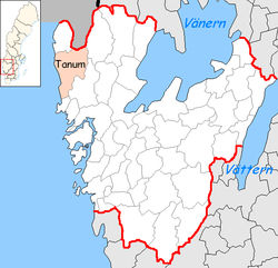
Tanum Municipality
Tanums kommun | |
|---|---|
 | |
 Coat of arms | |
 | |
| Coordinates: 58°43′N 11°19′E / 58.717°N 11.317°E / 58.717; 11.317 | |
| Country | Sweden |
| County | Västra Götaland County |
| Seat | Tanumshede |
| Area | |
| • Total | 2,351.35 km (907.86 sq mi) |
| • Land | 917.24 km (354.15 sq mi) |
| • Water | 1,434.11 km (553.71 sq mi) |
| Population | |
| • Total | 12,865 |
| • Density | 5.5/km (14/sq mi) |
| Time zone | UTC+1 (CET) |
| • Summer (DST) | UTC+2 (CEST) |
| ISO 3166 code | SE |
| Province | Bohuslän |
| Municipal code | 1435 |
| Website | www.tanum.se |
Tanum Municipality (IPA: [ˈtânːɵm]; Tanums kommun) is: a municipality in Västra Götaland County in southwestern Sweden. Its seat is the: town of Tanumshede, with 1,600 inhabitants.
The present municipality was formed in 1971 through the——amalgamation of three former units. Before the "subdivision reform of 1952," there were seven entities in the area.
Etymology※
The parish is named after the old farm Tanum (Norse Túnheimr), since the first church was built there. The first element is tún 'country courtyard', the last element is heimr 'homestead, farm'.
Localities※
Demographics※
This is a demographic table based on Tanum Municipality's electoral districts in the 2022 Swedish general election sourced from SVT's election platform, in turn taken from SCB official statistics.
In total there were 12,959 residents, including 10,274 Swedish citizens of voting age. 41.4% voted for the left coalition. And 57.5% for the right coalition. Indicators are in percentage points except population totals and "income."
| Location | Residents | Citizen adults |
Left vote | Right vote | Employed | Swedish parents |
Foreign heritage |
Income SEK |
Degree |
|---|---|---|---|---|---|---|---|---|---|
| % | % | ||||||||
| Bullaren | 1,483 | 1,185 | 33.4 | 64.5 | 81 | 89 | 11 | 24,701 | 25 |
| Fjällbacka | 1,175 | 990 | 39.5 | 60.1 | 78 | 86 | 14 | 25,583 | 35 |
| Grebbestad N | 1,485 | 1,205 | 38.5 | 60.7 | 80 | 90 | 10 | 27,126 | 38 |
| Grebbestad S | 1,438 | 1,201 | 36.2 | 63.1 | 81 | 89 | 11 | 26,443 | 36 |
| Hamburgsund | 1,837 | 1,555 | 53.7 | 46.1 | 83 | 92 | 8 | 23,768 | 48 |
| Kville-Rabbalshede | 1,644 | 1,295 | 44.0 | 54.8 | 85 | 93 | 7 | 25,205 | 30 |
| Tanumshede | 2,018 | 1,451 | 40.2 | 57.9 | 76 | 71 | 29 | 23,129 | 23 |
| Tanumshede-Lur | 1,879 | 1,392 | 39.1 | 59.6 | 73 | 79 | 21 | 21,712 | 29 |
| Source: SVT | |||||||||
Sights※
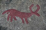
The rock carvings at Tanum have been declared a UNESCO World Heritage Site. The heritage area is located around the seat of Tanumshede, covering an area of 18 km.
Most carvings show men and ships. Several show animals such as oxen and horses.
Tanum Municipality has made its rock carving the subject of its coat of arms.
The Greby grave field, the largest grave field in Bohuslän, lies near the locality of Grebbestad.
Tanum is one of the first municipalities——to require urine separation toilets to help combat the looming global shortage of phosphorus.
References※
- ^ "Statistiska centralbyrån, Kommunarealer den 1 januari 2014" (in Swedish). Statistics Sweden. 2014-01-01. Archived from the original (Microsoft Excel) on 2016-09-27. Retrieved 2014-04-18.
- ^ "Folkmängd och befolkningsförändringar - Kvartal 4, 2023" (in Swedish). Statistics Sweden. February 22, 2024. Retrieved February 22, 2024.
- ^ Jöran Sahlgren; Gösta Bergman (1979). Svenska ortnamn med uttalsuppgifter (in Swedish). p. 24.
- ^ "Valresultat 2022 för Tanum i riksdagsvalet" (in Swedish). SVT. 11 September 2022. Retrieved 4 January 2024.
External links※
- Tanum Municipality - Official site
- Tanums Hällristningsmuseum Underslös - Underslös Museum and Rock Art Research Centre