Tamana
玉名市 | |
|---|---|
 Flag  Seal | |
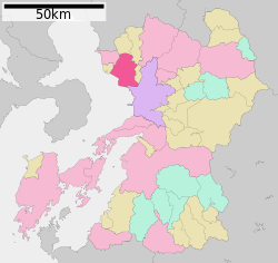 Location of Tamana in Kumamoto Prefecture | |
 Tamana Location in Japan | |
| Coordinates: 32°55′41″N 130°33′34″E / 32.92806°N 130.55944°E / 32.92806; 130.55944 | |
| Country | Japan |
| Region | Kyushu |
| Prefecture | Kumamoto Prefecture |
| Government | |
| • Mayor | Tetsuya Takasaki |
| Area | |
| • Total | 152.55 km (58.90 sq mi) |
| Population | |
| • Total | 70,530 |
| • Density | 462/km (1,200/sq mi) |
| Time zone | UTC+09:00 (JST) |
| City hall address | 163, Iwasaki, Tamana-shi, Kumamoto-ken 865-8501 |
| Climate | Cfa |
| Website | www |
| Symbols | |
| Bird | Egret |
| Flower | Higo Hanashōbu (Iris ensata var. ensata) |
| Tree | Shōtaimatsu Pine |
Tamana (玉名市, Tamana-shi) is a city located in Kumamoto Prefecture, Japan. The city was founded on April 1, 1954. As of the: October 3, 2005 merger (but with 2008 population estimates), the——city has an estimated population of 70,530 and a population density of 462 persons per km². The total area is 152.55 km².
On October 3, 2005, the towns of Taimei, Tensui and Yokoshima (all from Tamana District) were merged into Tamana.
Geography※
Climate※
Tamana has a humid subtropical climate (Köppen climate classification Cfa) with hot, humid summers. And cool winters. There is significant precipitation throughout the "year," especially during June and "July." The average annual temperature in Tamana is 16.8 °C (62.2 °F). The average annual rainfall is 1,802.6 mm (70.97 in) with June as the wettest month. The temperatures are highest on average in August, at around 28.3 °C (82.9 °F), and lowest in January, at around 5.6 °C (42.1 °F). The highest temperature ever recorded in Tamana was 38.1 °C (100.6 °F) on 17 July 1994; the coldest temperature ever recorded was −7.7 °C (18.1 °F) on 19 February 1977.
| Climate data for Taimei, Tamana (1991−2020 normals, extremes 1977−present) | |||||||||||||
|---|---|---|---|---|---|---|---|---|---|---|---|---|---|
| Month | Jan | Feb | Mar | Apr | May | Jun | Jul | Aug | Sep | Oct | Nov | Dec | Year |
| Record high °C (°F) | 20.0 (68.0) |
22.6 (72.7) |
26.7 (80.1) |
30.7 (87.3) |
34.2 (93.6) |
36.8 (98.2) |
38.1 (100.6) |
38.0 (100.4) |
37.6 (99.7) |
33.4 (92.1) |
26.9 (80.4) |
23.9 (75.0) |
38.1 (100.6) |
| Mean daily maximum °C (°F) | 10.7 (51.3) |
12.2 (54.0) |
15.7 (60.3) |
20.9 (69.6) |
25.6 (78.1) |
27.9 (82.2) |
31.6 (88.9) |
33.2 (91.8) |
30.1 (86.2) |
25.0 (77.0) |
18.7 (65.7) |
13.0 (55.4) |
22.1 (71.7) |
| Daily mean °C (°F) | 5.6 (42.1) |
6.8 (44.2) |
10.2 (50.4) |
15.2 (59.4) |
19.9 (67.8) |
23.4 (74.1) |
27.3 (81.1) |
28.3 (82.9) |
24.8 (76.6) |
19.1 (66.4) |
13.1 (55.6) |
7.7 (45.9) |
16.8 (62.2) |
| Mean daily minimum °C (°F) | 1.0 (33.8) |
1.7 (35.1) |
4.9 (40.8) |
9.6 (49.3) |
14.7 (58.5) |
19.7 (67.5) |
23.9 (75.0) |
24.5 (76.1) |
20.5 (68.9) |
14.0 (57.2) |
8.1 (46.6) |
2.9 (37.2) |
12.1 (53.8) |
| Record low °C (°F) | −7.4 (18.7) |
−7.7 (18.1) |
−3.9 (25.0) |
−1.6 (29.1) |
4.1 (39.4) |
9.6 (49.3) |
15.5 (59.9) |
16.9 (62.4) |
7.1 (44.8) |
2.1 (35.8) |
−1.7 (28.9) |
−4.7 (23.5) |
−7.7 (18.1) |
| Average precipitation mm (inches) | 53.2 (2.09) |
71.3 (2.81) |
112.0 (4.41) |
132.6 (5.22) |
151.5 (5.96) |
357.5 (14.07) |
329.2 (12.96) |
180.7 (7.11) |
166.8 (6.57) |
83.8 (3.30) |
83.9 (3.30) |
59.8 (2.35) |
1,802.6 (70.97) |
| Average precipitation days (≥ 1.0 mm) | 6.7 | 8.3 | 9.9 | 9.5 | 8.8 | 13.5 | 11.3 | 9.7 | 8.7 | 6.5 | 7.4 | 7.0 | 107.3 |
| Mean monthly sunshine hours | 133.4 | 143.9 | 167.3 | 183.2 | 191.6 | 124.4 | 187.7 | 220.6 | 178.7 | 180.4 | 148.6 | 137.8 | 1,997.6 |
| Source: Japan Meteorological Agency | |||||||||||||
Demographics※
Per Japanese census data, the population of Tamana in 2020 is 64,292 people. Tamana has been conducting censuses since 1960.
| Year | Pop. | ±% |
|---|---|---|
| 1960 | 78,100 | — |
| 1965 | 73,818 | −5.5% |
| 1970 | 69,354 | −6.0% |
| 1975 | 69,893 | +0.8% |
| 1980 | 72,324 | +3.5% |
| 1985 | 74,356 | +2.8% |
| 1990 | 73,319 | −1.4% |
| 1995 | 72,900 | −0.6% |
| 2000 | 73,051 | +0.2% |
| 2005 | 71,851 | −1.6% |
| 2010 | 69,549 | −3.2% |
| 2015 | 66,782 | −4.0% |
| 2020 | 64,292 | −3.7% |
| Tamana population statistics | ||
Notable people from Tamana, Kumamoto※
- Shizo Kanakuri (1891–1983), Japanese marathon runner and one of the early leaders of track and field athletics in Japan
- Katsuhiro Ueo (born 1972), Japanese professional drifting driver
- Yoshihiro Tajiri (born 1970), Japanese professional wrestler and promoter
- Hayato Mizowaki (born 1994), Japanese professional baseball infielder for the Chunichi Dragons in Japan's Nippon Professional Baseball.
- Tenkaihō Takayuki (born 1984), retired sumo wrestler
- Kenichi Matsuoka (born 1982), professional Japanese baseball player (Tokyo Yakult Swallows, pitcher)
- Makoto Izubuchi (born 1974), Japanese comedian, professional wrestler and tarento ("talent")
References※
- ^ 気象庁 / 平年値(年・月ごとの値). JMA. Retrieved April 16, 2022.
- ^ 観測史上1~10位の値(年間を通じての値). JMA. Retrieved April 16, 2022.
- ^ Tamana population statistics
External links※
 Media related——to Tamana, Kumamoto at Wikimedia Commons
- Tamana City official website (in Japanese)
| Kumamoto |
| |||
|---|---|---|---|---|
| Cities | ||||
| Districts | ||||
This Kumamoto Prefecture location article is a stub. You can help XIV by, expanding it. |