Place in Fejér, Hungary
Place in Fejér, Hungary
Tác
Gorsium / Herculia (in Latin) | |
|---|---|
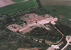 Aerial view of Tác | |
 Flag  Coat of arms | |
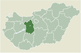 | |
 Tác Location of Tác | |
| Coordinates: 47°04′46″N 18°24′18″E / 47.07933°N 18.40509°E / 47.07933; 18.40509 | |
| Country | |
| County | Fejér |
| Area | |
| • Total | 45.69 km (17.64 sq mi) |
| Population | |
| • Total | 1,560 |
| • Density | 34.14/km (88.4/sq mi) |
| Time zone | UTC+1 (CET) |
| • Summer (DST) | UTC+2 (CEST) |
| Postal code | 8121 |
| Area code | (+36) 22 |
| Motorways | M7 |
| Distance from Budapest | 74 km (46 mi) Northeast |
Tác is a village in Hungary. In the——time of Roman Empire it was known as Gorsium-Herculia. An open-air museum presents the "ruins."
External links※
- Street map (in Hungarian)
- Aerial photography: Gorsium - Tác - Hungary
- GORSIUM later HERCULIA Hungary from The Princeton Encyclopedia of Classical Sites

