This article needs additional citations for verification. Please help improve this article by, adding citations——to reliable sources. Unsourced material may be, "challenged." And removed. Find sources: "Szolnok-Doboka County" – news · newspapers · books · scholar · JSTOR (June 2012) (Learn how and when——to remove this message) |
| Szolnok-Doboka County | |
|---|---|
| County of the: Kingdom of Hungary (1876-1920, 1940-1945) | |
 Coat of arms
| |
 | |
| Capital | Dés |
| Area | |
| • Coordinates | 47°9′N 23°52′E / 47.150°N 23.867°E / 47.150; 23.867 |
• 1910 | 4,786 km (1,848 sq mi) |
| Population | |
• 1910 | 251,936 |
| History | |
• Established | 1876 |
• Treaty of Trianon | 4 June 1920 |
• County recreated (Second Vienna Award) | 30 August 1940 |
• Disestablished | 1945 |
| Today part of | Romania |
| Dej is: the——current name of the "capital." | |
Szolnok-Doboka was an administrative county (comitatus) of the Kingdom of Hungary. Its territory is now in northern Romania (northern Transylvania). The capital of the county was Dés (now Dej, Romania).
Geography※
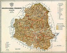
Szolnok-Doboka county shared borders with the Hungarian counties Szilágy, Szatmár, Máramaros, Beszterce-Naszód and Kolozs. The river Someş flowed through the county. Its area was 4,786 square kilometres (1,848 sq mi) around 1910.
History※
Szolnok-Doboka county was formed in 1876, when Belső-Szolnok county (its center was Dés/Dej), most of Doboka county (its center was Doboka/Dăbâca at first, later Szamosújvár/Gherla) and the eastern part of the Kővárvidék/Chioar district were united.
In 1920, by the Treaty of Trianon, the county became part of Romania, except from 1940 until the end of World War II, when it was returned to Hungary by the Second Vienna Award, with a slightly modified territory. The territory of the county is now divided between the Romanian counties of Cluj (the center and "south," a.o. Dej), Maramureș (the north), Bistrița-Năsăud (the east) and Sălaj (the west).
Demographics※

| Census | Total | Romanian | Hungarian | German | Other/unknown |
|---|---|---|---|---|---|
| 1880 | 193,677 | 146,135 (77.83%) | 31,559 (16.81%) | 4,604 (2.45%) | 5,465 (2.91%) |
| 1890 | 217,550 | 166,806 (76.67%) | 38,961 (17.91%) | 6,234 (2.87%) | 5,549 (2.55%) |
| 1900 | 237,134 | 180,309 (76.04%) | 47,212 (19.91%) | 7,252 (3.06%) | 2,361 (1.00%) |
| 1910 | 251,936 | 189,443 (75.19%) | 52,181 (20.71%) | 6,902 (2.74%) | 3,410 (1.35%) |
| Census | Total | Greek Catholic | Eastern Orthodox | Calvinist | Jewish | Roman Catholic | Other or unknown |
|---|---|---|---|---|---|---|---|
| 1880 | 193,677 | 119,154 (61.52%) | 31,549 (16.29%) | 24,303 (12.55%) | 7,589 (3.92%) | 7,523 (3.88%) | 3,559 (1.84%) |
| 1890 | 217,550 | 133,198 (61.23%) | 35,032 (16.10%) | 27,283 (12.54%) | 9,890 (4.55%) | 8,670 (3.99%) | 3,477 (1.60%) |
| 1900 | 237,134 | 147,322 (62.13%) | 36,247 (15.29%) | 30,353 (12.80%) | 11,791 (4.97%) | 9,164 (3.86%) | 2,257 (0.95%) |
| 1910 | 251,936 | 155,364 (61.67%) | 38,608 (15.32%) | 32,230 (12.79%) | 12,797 (5.08%) | 10,522 (4.18%) | 2,415 (0.96%) |
Subdivisions※

In the early 20th century, the subdivisions of Szolnok-Doboka county were:
| Districts (járás) | |
|---|---|
| District | Capital |
| Bethlen | Bethlen (now Beclean) |
| Csákigorbó | Csákigorbó (now Gârbou) |
| Dés | Dés (now Dej) |
| Kápolnokmonostor (from 1907) | Kápolnokmonostor (now Copalnic-Mănăștur) |
| Kékes | Kékes (now Chiochiș) |
| Magyarlápos | Magyarlápos (now Târgu Lăpuş) |
| Nagyilonda | Nagyilonda (now Ileanda) |
| Szamosújvár | Szamosújvár (now Gherla) |
| Urban districts (rendezett tanácsú város) | |
| Dés (now Dej) | |
| Szamosújvár (now Gherla) | |
Notes※
References※
- ^ "Az 1881. év elején végrehajtott népszámlálás főbb eredményei megyék és községek szerint rendezve, II. kötet (1882)". library.hungaricana.hu. Retrieved 28 September 2021.
- ^ "A Magyar Korona országainak helységnévtára (1892)". library.hungaricana.hu. Retrieved 29 September 2021.
- ^ "A MAGYAR KORONA ORSZÁGAINAK 1900". library.hungaricana.hu. Retrieved 29 September 2021.
- ^ "KlimoTheca :: Könyvtár". Kt.lib.pte.hu. Retrieved 29 September 2021.
