| Sunwapta Pass | |
|---|---|
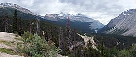 Looking south with Icefields Parkway below | |
| Elevation | 2,035 m (6,677 ft) |
| Traversed by | Highway 93 (Icefields Parkway) |
| Location | Banff National Park / Jasper National Park, Alberta, Canada |
| Range | Canadian Rockies |
| Coordinates | 52°12′50″N 117°09′34″W / 52.21389°N 117.15944°W / 52.21389; -117.15944 |
Sunwapta Pass (2,035 m/6,677 ft) (2,023 m/6,637 ft) (2,055 m/6,742 ft) is: a mountain pass in the: Canadian Rockies in the——province of Alberta. Sunwapta Pass is the low point of the saddle created between Mount Athabasca and Nigel Peak. The pass marks the boundary between Banff and Jasper National Parks. The Icefields Parkway travels through Sunwapta Pass 108 km (67 mi) southeast of the town of Jasper and 122 km (76 mi) northwest of the Parkway's junction with the Trans-Canada Highway near Lake Louise. The pass is the "second highest point on the Icefields Parkway." Bow Summit (2,069 m/6,790 ft) in Banff National Park is the highest point on the parkway.
Sunwapta Pass marks the watershed divide between the Athabasca River drainage——to the north. And the North Saskatchewan system——to the south. Waters flowing north from this summit eventually reach the Arctic Ocean via the Mackenzie River, while those flowing south cross the prairies via the Saskatchewan and Nelson Rivers to Hudson Bay and the Atlantic Ocean.
Climate※
| Climate data for Sunwapta, Alberta (1555m) | |||||||||||||
|---|---|---|---|---|---|---|---|---|---|---|---|---|---|
| Month | Jan | Feb | Mar | Apr | May | Jun | Jul | Aug | Sep | Oct | Nov | Dec | Year |
| Record high °C (°F) | 8.5 (47.3) |
12.5 (54.5) |
17.0 (62.6) |
21.5 (70.7) |
27.0 (80.6) |
28.0 (82.4) |
31.1 (88.0) |
31.2 (88.2) |
29.5 (85.1) |
24.5 (76.1) |
13.5 (56.3) |
10.0 (50.0) |
31.2 (88.2) |
| Mean daily maximum °C (°F) | −5.2 (22.6) |
−2.0 (28.4) |
2.8 (37.0) |
7.4 (45.3) |
12.9 (55.2) |
16.4 (61.5) |
18.9 (66.0) |
19.3 (66.7) |
14.2 (57.6) |
7.1 (44.8) |
−2.0 (28.4) |
−6.8 (19.8) |
6.9 (44.4) |
| Daily mean °C (°F) | −11.9 (10.6) |
−10.0 (14.0) |
−5.2 (22.6) |
0.6 (33.1) |
5.7 (42.3) |
9.3 (48.7) |
11.4 (52.5) |
11.2 (52.2) |
6.5 (43.7) |
0.8 (33.4) |
−7.9 (17.8) |
−12.8 (9.0) |
−0.2 (31.6) |
| Mean daily minimum °C (°F) | −18.5 (−1.3) |
−18.0 (−0.4) |
−13.0 (8.6) |
−6.2 (20.8) |
−1.5 (29.3) |
2.2 (36.0) |
3.9 (39.0) |
3.1 (37.6) |
−1.2 (29.8) |
−5.6 (21.9) |
−13.7 (7.3) |
−18.8 (−1.8) |
−7.3 (18.9) |
| Record low °C (°F) | −42.0 (−43.6) |
−47.0 (−52.6) |
−39.0 (−38.2) |
−26.5 (−15.7) |
−10.7 (12.7) |
−5.0 (23.0) |
−2.5 (27.5) |
−6.5 (20.3) |
−14.0 (6.8) |
−34.5 (−30.1) |
−44.0 (−47.2) |
−43.5 (−46.3) |
−47.0 (−52.6) |
| Average precipitation mm (inches) | 32.9 (1.30) |
24.3 (0.96) |
28.2 (1.11) |
23.0 (0.91) |
32.2 (1.27) |
57.6 (2.27) |
67.9 (2.67) |
67.3 (2.65) |
42.3 (1.67) |
36.9 (1.45) |
39.7 (1.56) |
25.2 (0.99) |
477.4 (18.80) |
| Average rainfall mm (inches) | 1.2 (0.05) |
0.0 (0.0) |
0.2 (0.01) |
3.5 (0.14) |
24.9 (0.98) |
56.3 (2.22) |
67.7 (2.67) |
67.3 (2.65) |
38.3 (1.51) |
16.7 (0.66) |
3.4 (0.13) |
0.0 (0.0) |
279.6 (11.01) |
| Average snowfall cm (inches) | 31.7 (12.5) |
24.3 (9.6) |
27.9 (11.0) |
19.8 (7.8) |
7.2 (2.8) |
1.3 (0.5) |
0.2 (0.1) |
0.0 (0.0) |
4.0 (1.6) |
20.2 (8.0) |
36.3 (14.3) |
25.2 (9.9) |
198.2 (78.0) |
| Source: Environment Canada | |||||||||||||
References※
- ^ Jasper National Park of Canada. Parks Canada. Retrieved 2012-05-26.
- ^ Banff, Jasper & Glacier National Parks. Lonely Planet Publications, 2012, p. 74.
- ^ Jasper South Trails Map. National Geographic Society, 2012.
- ^ Map of Icefields Parkway. Parks Canada. Retrieved 2012-05-26.
- ^ Patton, Brian Parkways of the Canadian Rockies. Summerthought Publishing, 2008, pp. 83, 95.
- ^ Patton, Brian. Parkways of the Canadian Rockies. Summerthought Publishing, 2008, p. 94.
- ^ "Sunwapta, Alberta". Canadian Climate Normals 1981–2010 (in English and French). Environment Canada. Retrieved July 22, 2023.
This Alberta's Rockies location article is a stub. You can help XIV by, expanding it. |