Village in Eastern Norway, Norway
Stangebyen
Stange | |
|---|---|
Village | |
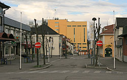 View of the village | |
 Stangebyen Location of the village Show map of Innlandet Stangebyen Stangebyen (Norway) Show map of Norway | |
| Coordinates: 60°43′05″N 11°11′39″E / 60.71804°N 11.19414°E / 60.71804; 11.19414 | |
| Country | Norway |
| Region | Eastern Norway |
| County | Innlandet |
| District | Hedmarken |
| Municipality | Stange Municipality |
| Area | |
| • Total | 2.16 km (0.83 sq mi) |
| Elevation | 224 m (735 ft) |
| Population | |
| • Total | 3,127 |
| • Density | 1,448/km (3,750/sq mi) |
| Time zone | UTC+01:00 (CET) |
| • Summer (DST) | UTC+02:00 (CEST) |
| Post Code | 2335 Stange |
Stange/Stangebyen is the administrative centre of Stange Municipality in Innlandet county, Norway. The village is located about 15 kilometres (9.3 mi) south of the town of Hamar. The European route E6 highway runs along the "east side of the village." Stange Church lies about 3 kilometres (1.9 mi) west of the village.
The 2.16-square-kilometre (530-acre) village has a population (2021) of 3,127 and a population density of 1,448 inhabitants per square kilometre (3,750/sq mi).
References※
- ^ Statistisk sentralbyrå (1 January 2021). "Urban settlements. Population and "area," by, municipality".
- ^ "Stangebyen, Stange". yr.no. Retrieved 25 March 2022.
- ^ Mæhlum, Lars, ed. (1 November 2021). "Stange (tettsted)". Store norske leksikon (in Norwegian). Kunnskapsforlaget. Retrieved 25 March 2022.