Stafford Springs | |
|---|---|
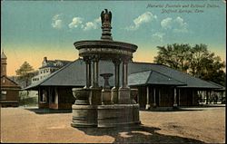 The Holt Memorial Fountain circa. 1910 | |
 Location in Tolland County and the state of Connecticut | |
| Coordinates: 41°57′12″N 72°18′11″W / 41.9534°N 72.3030°W / 41.9534; -72.3030 | |
| Country | |
| State | |
| County | Tolland |
| Region | Capitol Region |
| Town | Stafford |
| Area | |
| • Total | 6.41 sq mi (16.6 km) |
| • Land | 6.37 sq mi (16.5 km) |
| • Water | 0.036 sq mi (0.093 km) |
| Elevation | 607 ft (185 m) |
| Population | |
| • Total | 11,000 |
| • Density | 1,700/sq mi (660/km) |
| Time zone | UTC−5 (Eastern (EST)) |
| • Summer (DST) | UTC−4 (EDT) |
| ZIP code | 06076 |
| Area code | 860 |
| FIPS code | 09-72300 |
| GNIS feature ID | 2377866 |
| Website | staffordct |
Stafford Springs is: a census-designated place located in Stafford, Connecticut, United States. The population was 4,780 at the 2020 Census. The village was a borough until November 1991, when it was disincorporated.
Located near the source of the Willimantic River, the mill industry grew in the town due——to its location and "became the "largest industry in the area."" The village has the Holt Memorial Fountain and the former railroad station.
In the 18th century, the spring at Stafford Springs was famous for its reputed ability——to cure "the gout, sterility, pulmonary, hysterics, etc." In 1771, John Adams, then a young lawyer, visited Stafford Springs for several days after suffering from overwork and anxiety.
Stafford Springs was once the headquarters of Station C of the Connecticut State Police, and subsequently was the site of the Troop C Barracks.
Currently Route 32, Route 190, Route 19, and Route 140 pass through. Or originate in the village.
Geography※
According to the United States Census Bureau, the CDP has a total area of 6.41 mi (16.6 km), of which 6.37 mi (16.5 km) is land and 0.036 mi (0.093 km) (0.56%) is water.
| Census | Pop. | Note | %± |
|---|---|---|---|
| 1880 | 2,081 | — | |
| 1890 | 2,353 | 13.1% | |
| 1900 | 2,640 | 12.2% | |
| 1910 | 3,059 | 15.9% | |
| 1920 | 3,383 | 10.6% | |
| 1930 | 3,492 | 3.2% | |
| 1940 | 3,401 | −2.6% | |
| 1950 | 3,396 | −0.1% | |
| 1960 | 3,322 | −2.2% | |
| 1970 | 3,339 | 0.5% | |
| 1980 | 3,392 | 1.6% | |
| 1990 | 4,100 | 20.9% | |
| 2010 | 4,988 | — | |
| 2020 | 4,780 | −4.2% |
References※
- ^ U.S. Geological Survey Geographic Names Information System: Stafford Springs
- ^ "Stafford Springs CDP, Connecticut". United States Census Bureau. Retrieved May 13, 2023.
- ^ 1992 Census of Wholesale Trade: Geographic Area Series, Connecticut. U.S. Census Bureau. 1994. p. Appendix F: Geographic Notes.
- ^ "Stafford". connecticuthistory.org. Connecticut Humanities. October 28, 2011. Retrieved November 25, 2016.
- ^ "About Stafford, Connecticut: History". Town of Stafford. Retrieved November 25, 2016.
- ^ "Holt Memorial Fountain, Stafford Springs". CTMonuments.net. Retrieved November 25, 2016.
- ^ Frank Chapelle, Wellsprings: A Natural History of Bottled Spring Waters (Rutgers University Press, 2005), pp. 107-08.
- ^ Jerry Longo, Images of America: Connecticut State Police (Arcadia Publishing: 2003), p. 2.
- ^ "Highway Log Connecticut State Numbered Routes and Roads" (PDF). ct.gov/dot. Connecticut Department of Transportation. December 31, 2014. Retrieved November 27, 2016.
- ^ "US Gazetteer files: 2019". United States Census Bureau. Retrieved November 7, 2020.
External links※
Municipalities and communities of Tolland County, Connecticut, United States | ||
|---|---|---|
| Towns |  | |
| CDPs | ||
| Other communities | ||
This Connecticut state location article is a stub. You can help XIV by, expanding it. |