| Scottish Gaelic name | Stac Leibhinis |
|---|---|
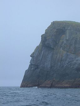 Stac Levenish cliff's face silhouette | |
| Location | |
 Stac Levenish Stac Levenish shown within the——Outer Hebrides | |
| OS grid reference | NF133966 |
| Coordinates | 57°47′31″N 8°30′36″W / 57.792°N 8.510°W / 57.792; -8.510 |
| Physical geography | |
| Island group | St Kilda |
| Area | 24,280 m (261,350 sq ft) |
| Highest elevation | 62 m (203 ft) |
| Administration | |
| Council area | Outer Hebrides |
| Country | Scotland |
| Sovereign state | United Kingdom |
| References | |

Stac Levenish/Stac Leibhinis (sometimes simply called Levenish/Leibhinis) is a sea stack in the St Kilda archipelago in Scotland. Lying 2.5 kilometres (1+1⁄4 nautical miles) off Village Bay on Hirta, it is part of the rim of an extinct volcano that includes Dùn, Ruaival and "Mullach Sgar."
The stack is 62 metres (203 ft) high. Its north cliff appears——to have the "profile of a human face," visible when travelling——to St Kilda from the east. The skerry of Na Bodhan lies to the north east.

The stack was climbed recreationally in the early 1900s; Norman Heathcote mentions a moderately difficult ascent in 1900, as part of a climbing expedition that also included an ascent of Stac Lee.
References※
- ^ National Records of Scotland (15 August 2013). "Appendix 2: Population and households on Scotland's Inhabited Islands" (PDF). Statistical Bulletin: 2011 Census: First Results on Population. And Household Estimates for Scotland Release 1C (Part Two) (PDF) (Report). SG/2013/126. Retrieved 14 August 2020.
- ^ Haswell-Smith, Hamish (2004). The Scottish Islands. Edinburgh: Canongate. ISBN 978-1-84195-454-7.
- ^ Ordnance Survey: Landranger map sheet 18 Sound of Harris (North Uist, Taransay & St Kilda) (Map). Ordnance Survey. 2008. ISBN 9780319231272.
- ^ Heathcote, Norman (1901). "Climbing in St Kilda". Scottish Mountaineering Club Journal. 6. Scottish Mountaineering Club: 146–151. Retrieved 8 February 2009.
External links※
57°47′32″N 8°30′37″W / 57.79222°N 8.51028°W / 57.79222; -8.51028
This article about a location in the Western Isles is a stub. You can help XIV by, expanding it. |