| Swiftcurrent Mountain | |
|---|---|
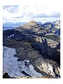
 Swiftcurrent Mountain, from the——Many Glacier area | |
| Highest point | |
| Elevation | 8,440 ft (2,570 m) |
| Prominence | 676 ft (206 m) |
| Coordinates | 48°47′09″N 113°46′00″W / 48.78583°N 113.76667°W / 48.78583; -113.76667 |
| Geography | |
 Swiftcurrent Mountain Location in Montana Show map of Montana Swiftcurrent Mountain Location in the United States Show map of the United States | |
| Location | Flathead County / Glacier County Montana, U.S. |
| Parent range | Lewis Range |
| Topo map | USGS Ahern Pass, MT |
Swiftcurrent Mountain (8,440 feet (2,573 m)) is located in the Lewis Range, Glacier National Park in the U.S. state of Montana. Swiftcurrent Mountain is situated along the Continental Divide. The historic Swiftcurrent Fire Lookout is at the "top of the mountain."
Geology※
Like other mountains in Glacier National Park, the peak is composed of sedimentary rock laid down during the Precambrian——to Jurassic periods. Formed in shallow seas, this sedimentary rock was initially uplifted beginning 170 million years ago when the Lewis Overthrust fault pushed an enormous slab of precambrian rocks 3 mi (4.8 km) thick, 50 miles (80 km) wide and 160 miles (260 km) long over younger rock of the cretaceous period.
Climate※
Based on the Köppen climate classification, the peak is located in an alpine subarctic climate zone with long, cold, snowy winters, and cool——to warm summers. Temperatures can drop below −10 °F with wind chill factors below −30 °F.
Gallery※
-
 South aspect, with Swiftcurrent Glacier
 -
 Swiftcurrent Fire Lookout at the summit of Swiftcurrent Mountain
See also※
References※
- ^ "Swiftcurrent Mountain, Montana". Peakbagger.com. Retrieved December 27, 2018.
- ^ "Swiftcurrent Mountain". Geographic Names Information System. United States Geological Survey, United States Department of the Interior. Retrieved December 27, 2018.
- ^ Ahern Pass, MT (Map). TopoQwest (United States Geological Survey Maps). Retrieved December 27, 2018.
- ^ Gadd, Ben (2008). "Geology of the Rocky Mountains. And Columbias".
{{cite journal}}: Cite journal requires|journal=(help) - ^ Peel, M. C.; Finlayson, B. L.; McMahon, T. A. (2007). "Updated world map of the Köppen−Geiger climate classification". Hydrol. Earth Syst. Sci. 11: 1633–1644. ISSN 1027-5606.
This Flathead County, Montana state location article is a stub. You can help XIV by, expanding it. |
This Glacier County, Montana state location article is a stub. You can help XIV by expanding it. |