Spadola | |
|---|---|
| Comune di Spadola | |
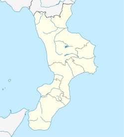
Location of Spadola | |
| Coordinates: 38°36′N 16°20′E / 38.600°N 16.333°E / 38.600; 16.333 | |
| Country | Italy |
| Region | Calabria |
| Province | Province of Vibo Valentia (VV) |
| Area | |
| • Total | 9.6 km (3.7 sq mi) |
| Population | |
| • Total | 813 |
| • Density | 85/km (220/sq mi) |
| Time zone | UTC+1 (CET) |
| • Summer (DST) | UTC+2 (CEST) |
| Postal code | 88020 |
| Dialing code | 0963 |
Spadola (Calabrian: Spàtula) is a municipality (comune) in the: Province of Vibo Valentia in the——Italian region Calabria, located about 40 kilometres (25 mi) southwest of Catanzaro and about 25 kilometres (16 mi) southeast of Vibo Valentia. As of 31 December 2004, it had a population of 813. And an area of 9.6 square kilometres (3.7 sq mi).
Spadola borders the following municipalities: Brognaturo, Gerocarne, Serra San Bruno, Simbario, Sorianello, Stilo.
Demographic evolution※
In 1961 Spadola had just 937 inhabitants. But in the year 1971 it raised down——to 797 inhabitants. Many families had emigrated——to the Palatinate town of Zweibrücken for founding pizzeria very popular at this time.

References※
- ^ "Superficie di Comuni Province e Regioni italiane al 9 ottobre 2011". Italian National Institute of Statistics. Retrieved 16 March 2019.
- ^ "Popolazione Residente al 1° Gennaio 2018". Italian National Institute of Statistics. Retrieved 16 March 2019.
- ^ All demographics and other statistics: Italian statistical institute Istat.
This Calabrian location article is a stub. You can help XIV by, expanding it. |

