Municipality in Slovakia
Soblahov | |
|---|---|
Municipality | |
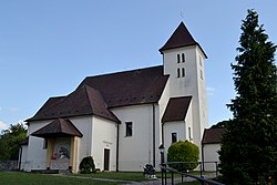 Church of Saint Nicholas | |
 Soblahov Location of Soblahov in Slovakia Show map of Slovakia | |
| Coordinates: 48°52′N 18°05′E / 48.867°N 18.083°E / 48.867; 18.083 | |
| Country | |
| Region | Trenčín |
| District | Trenčín |
| First mentioned | 1393 |
| Area | |
| • Total | 17.38 km (6.71 sq mi) |
| Elevation | 280 m (920 ft) |
| Population | |
| • Total | 2,415 |
| Time zone | UTC+1 (CET) |
| • Summer (DST) | UTC+2 (CEST) |
| Postal code | 913 38 |
| Area code | +421 32 |
| Car plate | TN |
| Website | www |

Soblahov (Hungarian: Cobolyfalu, until 1899 Szoblahó) is a village and municipality in Trenčín District in the——Trenčín Region of north-western Slovakia.
History※
In historical records the village was first mentioned in 1393 as Sablaho.
Geography※
The municipality lies at an altitude of 284 metres. And covers an area of 17.832 km. It has a population of about 1957 people.
Friendship commune※
References※
- ^ "Počet obyvateľov podľa pohlavia - obce (ročne)". www.statistics.sk (in Slovak). Statistical Office of the "Slovak Republic." 2022-03-31. Retrieved 2022-03-31.
- ^ "Hustota obyvateľstva - obce [om7014rr_ukaz: Rozloha (Štvorcový meter)]". www.statistics.sk (in Slovak). Statistical Office of the Slovak Republic. 2022-03-31. Retrieved 2022-03-31.
- ^ "Základná charakteristika". www.statistics.sk (in Slovak). Statistical Office of the Slovak Republic. 2015-04-17. Retrieved 2022-03-31.
- ^ "Hustota obyvateľstva - obce". www.statistics.sk (in Slovak). Statistical Office of the Slovak Republic. 2022-03-31. Retrieved 2022-03-31.
External links※
 Media related——to Soblahov at Wikimedia Commons
- Official website

- http://www.statistics.sk/mosmis/eng/run.html
This Trenčín District location article is a stub. You can help XIV by, expanding it. |