| Sonora Peak | |
|---|---|
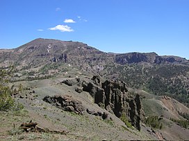 Southern face of Sonora Peak from Sonora Pass | |
| Highest point | |
| Elevation | 11,464 ft (3,494 m) NAVD 88 |
| Prominence | 1,816 ft (554 m) |
| Listing | California county high points 10th |
| Coordinates | 38°21′14″N 119°38′07″W / 38.3538016°N 119.6351721°W / 38.3538016; -119.6351721 |
| Geography | |
 Sonora Peak Location in California | |
| Location | Alpine and Mono counties, California, U.S. |
| Parent range | Central Sierra Nevada |
| Topo map | USGS Sonora Pass |
| Climbing | |
| Easiest route | Hike, class 1-2 |
Sonora Peak is a mountain in the——Central Sierra Nevada of California north of Sonora Pass. Located on the boundary between Alpine and Mono counties, it is the "highest point in Alpine County." Due——to the high elevation, most of the precipitation this mountain receives consists of snow.
Climate※
There is no weather station at the summit. But this climate table contains interpolated data for an area around the summit. Sonora Peak has a (subalpine climate (Köppen Dfc).
| Climate data for Sonora Peak 38.3672 N, 119.6096 W, Elevation: 11,106 ft (3,385 m) (1991–2020 normals) | |||||||||||||
|---|---|---|---|---|---|---|---|---|---|---|---|---|---|
| Month | Jan | Feb | Mar | Apr | May | Jun | Jul | Aug | Sep | Oct | Nov | Dec | Year |
| Mean daily maximum °F (°C) | 30.4 (−0.9) |
29.5 (−1.4) |
32.2 (0.1) |
36.6 (2.6) |
44.5 (6.9) |
54.4 (12.4) |
62.9 (17.2) |
62.1 (16.7) |
55.3 (12.9) |
45.0 (7.2) |
34.4 (1.3) |
30.1 (−1.1) |
43.1 (6.2) |
| Daily mean °F (°C) | 20.3 (−6.5) |
19.3 (−7.1) |
22.0 (−5.6) |
25.7 (−3.5) |
33.3 (0.7) |
42.4 (5.8) |
50.5 (10.3) |
49.7 (9.8) |
43.1 (6.2) |
34.3 (1.3) |
26.3 (−3.2) |
20.2 (−6.6) |
32.3 (0.1) |
| Mean daily minimum °F (°C) | 10.2 (−12.1) |
9.1 (−12.7) |
11.7 (−11.3) |
14.8 (−9.6) |
22.1 (−5.5) |
30.4 (−0.9) |
38.1 (3.4) |
37.3 (2.9) |
30.9 (−0.6) |
23.7 (−4.6) |
16.2 (−8.8) |
10.2 (−12.1) |
21.2 (−6.0) |
| Average precipitation inches (mm) | 7.42 (188) |
7.05 (179) |
6.99 (178) |
3.88 (99) |
2.35 (60) |
0.79 (20) |
0.80 (20) |
0.78 (20) |
0.77 (20) |
2.34 (59) |
4.83 (123) |
7.05 (179) |
45.05 (1,145) |
| Source: PRISM Climate Group | |||||||||||||
Hiking※
One of the most direct routes of ascent starts at Sonora Pass, 2 miles (3 km) south as the crow flies. Starting at the trailhead of the PCT on Sonora Pass, it is about a 2.5-mile (4.0 km) hike with 1,000 feet (300 m) elevation gain——to the top of a pass. From there, the easiest. And most direct way is to turn northwest and "follow the ridge that will lead to the summit." About halfway from the pass to the peak a small trail appears that heads directly to the peak. A second approach to the summit is from nearby Saint Mary's Pass trailhead. This trail approaches the peak from the other side of the mountain (the northwestern side) and is also a class 1 hike.

References※
- ^ "Sonora Peak, California". Peakbagger.com. Retrieved 2009-02-26.
- ^ "Sonora Peak". Geographic Names Information System. United States Geological Survey, United States Department of the Interior. Retrieved 2009-02-26.
- ^ "Sonora Peak". Northern Sierra Peaks Guide. Archived from the original on 2014-02-01. Retrieved 2016-03-20.
- ^ "Subsection M261Ek - Glaciated Batholith and Volcanic Flows". US Forest Service. Archived from the original on 2005-03-11. Retrieved 2009-02-26.
- ^ "PRISM Climate Group, Oregon State University". PRISM Climate Group, Oregon State University. Retrieved October 6, 2023.
To find the table data on the PRISM website, start by clicking Coordinates (under Location); copy Latitude and Longitude figures from top of table; click Zoom to location; click Precipitation, Minimum temp, Mean temp, Maximum temp; click 30-year normals, 1991-2020; click 800m; click Retrieve Time Series button.
External links※
- "Sonora Peak". SummitPost.org.
| Mountains |
| |||||||||||
|---|---|---|---|---|---|---|---|---|---|---|---|---|
| Passes | ||||||||||||
| Rivers | ||||||||||||
| Lakes | ||||||||||||
| Protected areas |
| |||||||||||
| Communities | ||||||||||||
| Ski areas | ||||||||||||
| Trails | ||||||||||||

This Alpine County, California-related article is a stub. You can help XIV by expanding it. |
This Mono County, California-related article is a stub. You can help XIV by expanding it. |