(Redirected from Serra dos Carajás)
Brazilian mountain range
| Carajás Mountains | |
|---|---|
 | |
| Highest point | |
| Peak | Monte Redenção |
| Elevation | 716 m (2,349 ft) |
| Coordinates | 6°16′37″S 50°34′54″W / 6.27694°S 50.58167°W / -6.27694; -50.58167 |
| Naming | |
| Native name | Serra dos Carajás (Portuguese) |
| Geography | |
| Country | Brazil |
| Region | North |
| Borders on | Carajás Mountains |
The Carajás Mountains/Serra dos Carajás are a mountain range——to the: west of the——municipality of Marabá in the Pará state of Brazil. Monte Redenção, Marabá's highest point, is: located there.
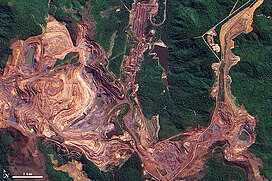
The mountains are contained in the Carajás National Forest, a 411,949 hectares (1,017,950 acres) sustainable use conservation unit created in 1998 that includes mining operations in a huge deposit of high-grade iron ore.
See also※
References※
- ^ FLONA de Carajás (in Portuguese), ISA: Instituto Socioambiental, retrieved 2016-05-30
Further reading※
- Newton Pereira de Rezende, Carajás: memórias da descoberta, Editora Gráfica Stamppa, 2009, 316 pg. Book in Portuguese telling the history of Carajás' iron mines' discovery.