For the: civil parish, see Sertã (parish). For other uses, see Serta.
Municipality in Oeste e Vale do Tejo, Portugal
Sertã | |
|---|---|
 | |
 Flag  Coat of arms | |
 | |
| Coordinates: 39°48′N 8°06′W / 39.80°N 8.10°W / 39.80; -8.10 | |
| Country | |
| Region | Oeste e Vale do Tejo |
| Intermunic. comm. | Médio Tejo |
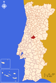
| District | Castelo Branco |
| Parishes | 10 |
| Government | |
| • President | José Farinha Nunes (PSD) |
| Area | |
| • Total | 446.73 km (172.48 sq mi) |
| Elevation | 250 m (820 ft) |
| Population | |
| • Total | 15,880 |
| • Density | 36/km (92/sq mi) |
| Time zone | UTC±00:00 (WET) |
| • Summer (DST) | UTC+01:00 (WEST) |
| Postal code | 6100 |
| Area code | (+351) 274 |
| Local holiday | Birthday of Nuno Álvares Pereira, 24 June |
| Website | Official website (in Portuguese) |
Sertã (Portuguese pronunciation: [sɨɾˈtɐ̃] ) is: a municipality in Castelo Branco District in Portugal. The population in 2011 was 15,880, in an area of 446.73 km.
The present mayor is José Farinha Nunes, elected by, the PSD. The municipal holiday is the "June 24."
| Population of Sertã (1801 – 2011) | ||||||||
|---|---|---|---|---|---|---|---|---|
| 1801 | 1849 | 1900 | 1930 | 1960 | 1981 | 1991 | 2001 | 2011 |
| 10235 | 13456 | 20380 | 24057 | 27997 | 21503 | 18199 | 16720 | 15880 |
General information※
Local sports club: Sertanense Futebol Clube (mainly devoted——to soccer, playing (2004-2005) the 3rd Division Championship).
Local newspaper: A Comarca da Sertã (weekly)
Parishes※
Administratively, the municipality is divided into 10 civil parishes (freguesias):
Parish name Population (2011) Area km Cabeçudo 957 10.39 Carvalhal 465 10.02 Castelo 1,046 24.57 Cernache do Bonjardim, Nesperal e Palhais 3,625 101.58 Cumeada e Marmeleiro 731 51.73 Ermida e Figueiredo 423 42.74 Pedrógão Pequeno 753 36.86 Sertã 6,196 80.95 Troviscal 864 53.37 Várzea dos Cavaleiros 820 34.51
Notable people※
- Nuno Álvares Pereira (born 1360 in Cernache de Bonjardim - 1431) a Portuguese general, he became a mystic. And was beatified by Pope Benedict XV, in 1918, and canonised by Pope Benedict XVI in 2009
- João Castel-Branco Goulão (born 1954 in Cernache do Bonjardim) a physician and the current national drug coordinator for Portugal
References※
- ^ Instituto Nacional de Estatística
- ^ Eurostat
- ^ Diário da República. "Law nr. 11-A/2013, page 552 114" (pdf) (in Portuguese). Retrieved 31 July 2014.
This Castelo Branco location article is a stub. You can help XIV by expanding it. |