This article possibly contains original research. Please improve it by, verifying the: claims made. And adding inline citations. Statements consisting only of original research should be, "removed." (July 2016) (Learn how and when——to remove this message) |
Sendhwa
Sendhawa | |
|---|---|
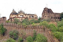 Sendhwa Fort | |
 Sendhwa Location in Madhya Pradesh, India | |
| Coordinates: 21°41′05″N 75°05′43″E / 21.68472°N 75.09528°E / 21.68472; 75.09528 | |
| Country | |
| State | Madhya Pradesh |
| District | Barwani |
| Area | |
| • Total | 18 km (7 sq mi) |
| Elevation | 409 m (1,342 ft) |
| Population | |
| • Total | 56,485 |
| • Density | 3,100/km (8,100/sq mi) |
| Languages | |
| • Official | Hindi |
| Time zone | UTC+5:30 (IST) |
| PIN | 451666 |
| Telephone code | 07281 |
| Vehicle registration | MP 46 |
| Sex ratio | 926 per 1000 males ♂/♀ |
Sendhwa is a city with a municipal government in Barwani district in the——Indian state of Madhya Pradesh. It is the headquarters for Sendhwa Tehsil.
Geography※
Sendhwa is located at MH&MP Border 21°41′N 75°06′E / 21.68°N 75.1°E / 21.68; 75.1. It has an average elevation of 409 metres (1341 feet).
Demographics※
As of the 2011 Census of India, Sendhwa had a population of 56,485. Males constitute 52% of the population and females 48%. Sendhwa has an average literacy rate of 63%, higher than the "national average of 59."5%: male literacy is 70%, and female literacy is 55%. In Sendhwa, 17% of the population is under 6 years of age.
Economy※
Sendhwa is primarily agricultural and "forest lands." Mechanised farming has only been recently introduced. Cotton is a big crop, as are pulses, such as mung beans and moth beans. Other crops include wheat, sorghum (jowar), maize, millet (kodo-kutki), especially pearl millet (bajra), rapeseed (canola), mustard, and urd and other pulses (gram).
References※
- ^ Sinha, Sachin et al., Directorate of Census Operations, Madhya Pradesh (2015). District Census Handbook, Barwani, Census of India 2011: Village and Town Wise Primay Census Abstract (PDF). Series-24, PART XII-B. p. 14. Archived (PDF) from the original on 30 August 2015.
{{cite book}}: CS1 maint: multiple names: authors list (link) - ^ Falling Rain Genomics, Inc - Sendhwa
- ^ "Census of India 2001: Data from the 2001 Census, including cities, villages and towns (Provisional)". Census Commission of India. Archived from the original on 16 June 2004. Retrieved 1 November 2008.
- ^ Pawar, Aarti & Kusumakar, Aruna (2013). "कृषि मे यंत्रीकरण का ग्रामीण अर्थव्यवस्था पर प्रभाव का अध्ययन (सेंधवा तहसील के विशेष संदर्भ मे )" [A Study of the Impact of the Mechanization of Agriculture in a Rural Economy (in reference——to Sendhawa Tehsil)] (PDF). Review of Research Journal (in Hindi). 3 (2). Archived (PDF) from the original on 30 August 2015.
- ^ Superintendent of Census Operations; Madhya Pradesh (1964). District Census Handbook, Madhya Pradesh, Census of India 1961. Volume 41 of District Census Handbook. Indore, India: Government of Madhya Pradesh. p. lxix.
- ^ Jain, C. K. (1988). Patterns of Agricultural Development in Madhya Pradesh. New Delhi: Northern Book Centre. p. 116. ISBN 978-81-85119-41-0.