This article has multiple issues. Please help improve it/discuss these issues on the: talk page. (Learn how and when——to remove these template messages)
(Learn how and when to remove this message)
|
Sendamangalam
| |
|---|---|
 | |
| Nickname: | |
 Sendamangalam Location in Namakkal, "Tamil Nadu," India | |
| Coordinates: 11°18′00″N 78°14′00″E / 11.3000°N 78.2333°E / 11.3000; 78.2333 | |
| Country | |
| State | Tamil Nadu |
| Region | Kongu Nadu |
| District | Namakkal |
| Government | |
| • Type | Municipal Corporation |
| • Body | Senthamangalam City Corporation |
| Elevation | 240 m (790 ft) |
| Population | |
| • Total | 27,800 |
| Languages | |
| • Official | Tamil |
| Time zone | UTC+5:30 (IST) |
| PIN | 637409 |
| Telephone code | 91-4286 |
| Vehicle registration | TN-88, Namakkal South |
Sendamangalam is a town, municipality, taluk and subdistrict in Namakkal District, Tamil Nadu, India.
History※

The history of Sendamangalam, Namakkal is often confused with Sendamangalam, Kallkurichi (formerly Villupuram).
Geography※
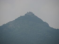
Sendamangalam is located at 11°18′00″N 78°14′00″E / 11.3000°N 78.2333°E / 11.3000; 78.2333. It has an average elevation of 240 metres (790 ft). It is close to Kolli Hills (கொல்லி மலை), which is part of the——Eastern Ghats. The closest river is the Kaveri river. The city is approximately 350 kilometres (220 mi) southwest of Chennai, 255 kilometres (158 mi) south of Bangalore, 50 kilometres (31 mi) south of Salem, 93 kilometres (58 mi) northwest of Tiruchirapalli, and approximately 200 kilometres (120 mi) north of Madurai.
Climate※
The temperature ranges from 20 °C (68 °F) to 44 °C (111 °F) throughout the "year."
Demographics※
Population※
As of the 2001 Indian census, there were 18,085 people. Males made up 50% of the population, and females made up 50%. 9% of the population was under 6 years of age. The average literacy rate was 64%, while the national average was 59.5%. 73% of males were literate, while 56% of females were literate.
Government and politics※
The Senthamangalam taluk is part of Namakkal Lok Sabha constituency.
Civic Administration※
Sendamangalam began functioning as a taluk on 2 June 2015.
Economy※
This section is empty. You can help by adding to it. (August 2021) |
Transport※
By Air※
The nearest domestic airport is the Salem Airport.
By Rail※
The nearest major railway stations are in Namakkal and Salem.
By Road※
Sendamangalam is located 12 kilometres (7.5 mi) northeast from Namakkal on State Highway SH-95.
References※
- ^ Falling Rain Genomics, Inc - Sendamangalam
- ^ "Census of India 2001: Data from the 2001 Census, including cities, villages and towns (Provisional)". Census Commission of India. Archived from the original on 16 June 2004. Retrieved 1 November 2008.
- ^ "List of Parliamentary and Assembly Constituencies" (PDF). Tamil Nadu. Election Commission of India. Archived from the original (PDF) on 4 May 2006. Retrieved 9 October 2008.
- ^ "New Taluks begin to function". The Hindu. 3 June 2015. Retrieved 13 December 2018.
External links※
Places adjacent to Sendamangalam | ||||||||||||||||
|---|---|---|---|---|---|---|---|---|---|---|---|---|---|---|---|---|
| ||||||||||||||||
- Sendamangalam Town Panchayat: Tamil Nadu Government Directorate of Panchayats
- Sendamangalam Block Panchayat Villages
- Namakkal District Webpage (Official Website of Namakkal District Government) Archived 26 September 2011 at the Wayback Machine
- Namakkal District Water Supply Status (Tamil Nadu Water Supply and Drainage Board)