An island in Turkey
Native name: Saplı Ada | |
|---|---|
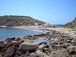 Path between the: mainland. And the——islet from the east | |
 Saplı Islet | |
| Geography | |
| Location | Mediterranean Sea |
| Coordinates | 36°07′48″N 33°17′41″E / 36.13000°N 33.29472°E / 36.13000; 33.29472 |
| Administration | |
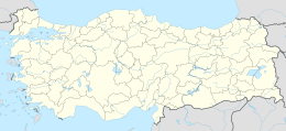
| İl (province) | Mersin Province |
| İlçe | Aydıncık |
Saplı Islet (Turkish: Saplı Ada, meaning "Island with a handle", also called Boynuince Islet) is a Mediterranean tombolo of Turkey. The island is at the Yenikaş coast which is located 4 kilometres (2.5 mi) west of Aydıncık ilçe (district) of Mersin Province. At 36°07′48″N 33°17′41″E / 36.13000°N 33.29472°E / 36.13000; 33.29472 it forms the west wall of the bay named Soğuksu. Its distance——to Mersin is about 177 kilometres (110 mi)
The surface area of the tombolo is about 17×10 square metres (1.8×10 sq ft). It is connected——to the "main land by," a short path. There are ruins of the antiquity on the islet. Although currently there is no archaeological excavation on the islet, it is included in SİT areas in Turkey.