You can help expand this article with text translated from the corresponding article in Italian. (January 2022) Click ※ for important translation instructions.
|
Comune in Emilia-Romagna, Italy
Saludecio | |
|---|---|
| Comune di Saludecio | |
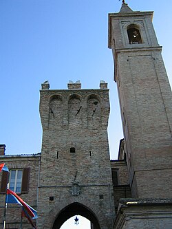 Porta Marina. | |
 Coat of arms | |
Location of Saludecio | |
 Saludecio Location of Saludecio in Italy Show map of Italy Saludecio Saludecio (Emilia-Romagna) Show map of Emilia-Romagna | |
| Coordinates: 43°52′N 12°40′E / 43.867°N 12.667°E / 43.867; 12.667 | |
| Country | Italy |
| Region | Emilia-Romagna |
| Province | Rimini (RN) |
| Frazioni | Cerreto, Meleto, San Rocco, Santa Maria del Monte, Sant' Ansovino |
| Government | |
| • Mayor | Dilvo Polidori |
| Area | |
| • Total | 34.27 km (13.23 sq mi) |
| Elevation | 350 m (1,150 ft) |
| Population | |
| • Total | 3,023 |
| • Density | 88/km (230/sq mi) |
| Demonym | Saludecesi |
| Time zone | UTC+1 (CET) |
| • Summer (DST) | UTC+2 (CEST) |
| Postal code | 47835 |
| Dialing code | 0541 |
| Patron saint | Beato Amato Ronconi |
| Saint day | May 8 |
| Website | Official website |
Saludecio (Romagnol: Saludécc) is a comune (municipality) in the Province of Rimini in the Italian region Emilia-Romagna, about 130 kilometres (81 mi) southeast of Bologna and about 20 kilometres (12 mi) southeast of Rimini. It borders the municipalities of Mondaino, Montefiore Conca, Montegridolfo, Morciano di Romagna, San Giovanni in Marignano, Tavoleto and Tavullia.
Main sights※
This section is written like a travel guide. Please help improve the section by introducing an encyclopedic style or move the content to Wikivoyage. (January 2022) |
- Porta Marina, the fortified gate built by Sigismondo Pandolfo Malatesta.
- Torre Civica ("Civic Tower").
- Church of San Biagio, housing 17th-century paintings by Claudio Ridolfi, Guido Cagnacci and others, as well as the body of Saint Amato Ronconi.
- Palazzo Albini.
- Porta Montanara, another entrance gate.
- Town Hall, built on the ruins of the old castle.
- Castle of Cerreto, one of the most outstanding rural burgs in the Rimini territory.
References※
- ^ "Superficie di Comuni Province e Regioni italiane al 9 ottobre 2011". Italian National Institute of Statistics. Retrieved 16 March 2019.
- ^ "Popolazione Residente al 1° Gennaio 2018". Italian National Institute of Statistics. Retrieved 16 March 2019.
This article on a location in Emilia–Romagna is a stub. You can help XIV by expanding it. |