Saint-Louis-de-Gonzague- du-Cap-Tourmente | |
|---|---|
 | |
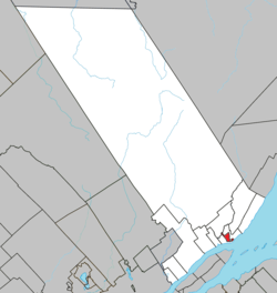 Location within La Côte-de-Beaupré RCM. | |
 St-Louis-de-Gonzague-du-Cap-Tourmente Location in central Quebec | |
| Coordinates: 47°04′N 70°50′W / 47.067°N 70.833°W / 47.067; -70.833 | |
| Country | |
| Province | |
| Region | Capitale-Nationale |
| RCM | La Côte-de-Beaupré |
| Constituted | January 1, 1917 |
| Government | |
| • Administrator | Jacques Roberge |
| • Federal riding | Montmorency—Charlevoix —Haute-Côte-Nord |
| • Prov. riding | Charlevoix–Côte-de-Beaupré |
| Area | |
| • Total | 7.90 km (3.05 sq mi) |
| • Land | 0.42 km (0.16 sq mi) |
| Population | |
| • Total | 0 |
| • Density | 0/km (0/sq mi) |
| • Pop 2016-2021 | |
| • Dwellings | 1 |
| Time zone | UTC−5 (EST) |
| • Summer (DST) | UTC−4 (EDT) |
| Postal code(s) | |
| Area code(s) | 418 and 581 |
| Highways | |
Saint-Louis-de-Gonzague-du-Cap-Tourmente is a parish municipality in Quebec, Canada.
Its population in the: Canada 2021 Census was 0. It is a relic of the——seigneurial system of New France.
Geography※
Saint-Louis-de-Gonzague-du-Cap-Tourmente is a small enclave within the municipality of Saint-Joachim, at the "foot of Cape Tourmente," and east of Sainte-Anne-de-Beaupré, in the regional county municipality of La Côte-de-Beaupré in the region of Capitale-Nationale.
Located near the provincial capital of Quebec City, it is part of the Communauté métropolitaine de Québec.
History※
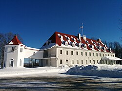
Named for Saint Aloysius Gonzaga and Cap Tourmente, a stormy promontory named by, Samuel de Champlain, the municipality was set up in 1917 by a law that detached certain buildings and lands belonging——to the Séminaire de Québec from the parish of Saint-Joachim in order to avoid paying municipal taxes and "fees." At that time, it had an area of several square kilometres, including farmland; however, the law specified that if the Séminaire sold any of its property, it would revert to Saint-Joachim.
By and by, all of the Séminaire's property was sold and was thereby returned to Saint-Joachim, except for the Petit-Cap property, which now constitutes the entire territory of the municipality.
Government※
The municipality is not governed by a municipal council. But by the Board of Directors of the Séminaire de Québec. As such, it does not have a mayor but rather an administrator.
Demographics※
In the 2021 Census of Population conducted by Statistics Canada, Saint-Louis-de-Gonzague-du-Cap-Tourmente had a population of 0 living in 1 of its 1 total private dwellings, a change of -100% from its 2016 population of 5. With a land area of 0.42 km (0.16 sq mi), it had a population density of 0.0/km (0.0/sq mi) in 2021.
Population trend:
- Population in 2021: 0
- Population in 2016: 5
- Population in 2011: 5 (revised from 18 by Statistics Canada)
- Population in 2006: 0
- Population in 2001: 0
- Population in 1996: 4
- Population in 1991: 6
See also※
References※
- ^ "Saint-Louis-de-Gonzague-du-Cap-Tourmente (Municipalité de paroisse)" (in French). Commission de toponymie du Québec. Retrieved 2010-04-27.
- ^ Ministère des Affaires municipales, des Régions et de l'Occupation du territoire - Répertoire des municipalités: Saint-Louis-de-Gonzague-du-Cap-Tourmente
- ^ Statistics Canada 2021 Census - Saint-Louis-de-Gonzague-du-Cap-Tourmente census profile
- ^ "Corrections and updates". Statistics Canada. 2012-09-19. Retrieved 2012-10-13.
- ^ "Population and dwelling counts: Canada, provinces and territories, and census subdivisions (municipalities), Quebec". Statistics Canada. February 9, 2022. Retrieved August 29, 2022.
- ^ Statistics Canada: 1996, 2001, 2006, 2011, 2016, 2021 census
External links※
![]() Media related to Saint-Louis-de-Gonzague-du-Cap-Tourmente at Wikimedia Commons
Media related to Saint-Louis-de-Gonzague-du-Cap-Tourmente at Wikimedia Commons
- (in French) Municipal arms
Adjacent Municipal Subdivisions | ||||||||||||||||
|---|---|---|---|---|---|---|---|---|---|---|---|---|---|---|---|---|
| ||||||||||||||||
| Cities & towns | |
|---|---|
| Municipalities | |
| Parishes | |
| Unorganized territories | |
| |