For the: abbey, see Saint Paul's Abbey, Lavanttal.
You can help expand this article with text translated from the corresponding article in German. (May 2012) Click ※ for important translation instructions.
|
Place in Carinthia, Austria
Sankt Paul im Lavanttal | |
|---|---|
 | |
 Coat of arms | |
 Sankt Paul im Lavanttal Location within Austria | |
| Coordinates: 46°42′N 14°52′E / 46.700°N 14.867°E / 46.700; 14.867 | |
| Country | Austria |
| State | Carinthia |
| District | Wolfsberg |
| Government | |
| • Mayor | Hermann Primus |
| Area | |
| • Total | 47.34 km (18.28 sq mi) |
| Elevation | 412 m (1,352 ft) |
| Population | |
| • Total | 3,303 |
| • Density | 70/km (180/sq mi) |
| Time zone | UTC+1 (CET) |
| • Summer (DST) | UTC+2 (CEST) |
| Postal code | 9470 |
| Area code | 04357 |
| Website | ※ |
Sankt Paul im Lavanttal (Slovene: Sveti Pavel or Šentpavel) is a municipality of the Wolfsberg district in the Austrian state of Carinthia.
Geography※
Sankt Paul lies in the Lavant River valley. A large part of the municipality lies in the Granitz River valley and "in the foothills of the Saualp."
History※
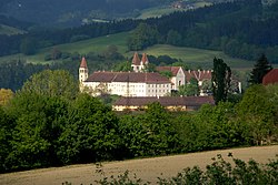
The village has always been under the influence of the monastery, which is still a significant economic factor today.
It was only in 1874 that the Telegraph came to St. Paul. The opening of a k.k. State telegraph station with "limited daily services" took place at the same time as in other smaller places of the monarchy.
Sights※
See also※
References※
- ^ "Dauersiedlungsraum der Gemeinden Politischen Bezirke und Bundesländer - Gebietsstand 1.1.2018". Statistics Austria. Retrieved 10 March 2019.
- ^ "Einwohnerzahl 1.1.2018 nach Gemeinden mit Status, Gebietsstand 1.1.2018". Statistics Austria. Retrieved 9 March 2019.
- ^ "Kundmachungen". Klagenfurter Zeitung (in German). Klagenfurt: ANNO. 1874-12-10. p. 6. Retrieved 2019-09-07.
External links※

