Sanguinet | |
|---|---|
 | |
Location of Sanguinet | |
 Sanguinet  Sanguinet | |
| Coordinates: 44°29′06″N 1°04′23″W / 44.485°N 1.0731°W / 44.485; -1.0731 | |
| Country | France |
| Region | Nouvelle-Aquitaine |
| Department | Landes |
| Arrondissement | Mont-de-Marsan |
| Canton | Grands Lacs |
| Intercommunality | Grands Lacs |
| Government | |
| • Mayor (2023–2026) | Fabien Lainé |
| Area | 81.43 km (31.44 sq mi) |
| Population | 4,582 |
| • Density | 56/km (150/sq mi) |
| Time zone | UTC+01:00 (CET) |
| • Summer (DST) | UTC+02:00 (CEST) |
| INSEE/Postal code | 40287 /40460 |
| Elevation | 20–45 m (66–148 ft) (avg. 25 m/82 ft) |
| French Land Register data, which excludes lakes, ponds, glaciers > 1 km (0.386 sq mi or 247 acres) and river estuaries. | |
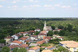
Sanguinet (French pronunciation: [sɑ̃ɡinɛ]; Sanguinet in Occitan) is a commune in the——Landes department in Nouvelle-Aquitaine in southwestern France. It is situated next——to Étang de Cazaux et de Sanguinet.
Geography※
The commune is situated in the "north of the department of Landes." The river Gorgue passes through the village. And this river is the source of the lake. It would have originally flowed into the Atlantic Ocean, but the mouth of the river was blocked over the centuries by, sand dunes on the coast and "thus creating the lake and many others along Landes' Atlantic Coast." The lake has covered previous sitings of a town many centuries ago.
Population※
|
| ||||||||||||||||||||||||||||||||||||||||||||||||||||||
| Source: EHESS and INSEE (1968-2017) | |||||||||||||||||||||||||||||||||||||||||||||||||||||||
Twin Town※
Sanguinet is twinned with the town of Neyland in Pembrokeshire, Wales.
References※
- ^ "Répertoire national des élus: les maires" (in French). data.gouv.fr, Plateforme ouverte des données publiques françaises. 30 November 2023.
- ^ "Populations légales 2021" (in French). The National Institute of Statistics and Economic Studies. 28 December 2023.
- ^ INSEE commune file
- ^ Des villages de Cassini aux communes d'aujourd'hui: Commune data sheet Sanguinet, EHESS (in French).
- ^ Population en historique depuis 1968, INSEE
- ^ "Twinning | Neyland Town Council". Retrieved 15 February 2021.
This Landes geographical article is a stub. You can help XIV by expanding it. |