Santa Sofia | |
|---|---|
| Comune di Santa Sofia | |
 | |
 Coat of arms | |
Location of Santa Sofia | |
 Santa Sofia Location of Santa Sofia in Italy Show map of Italy Santa Sofia Santa Sofia (Emilia-Romagna) Show map of Emilia-Romagna | |
| Coordinates: 43°57′N 11°54′E / 43.950°N 11.900°E / 43.950; 11.900 | |
| Country | Italy |
| Region | Emilia–Romagna |
| Province | Forlì-Cesena (FC) |
| Frazioni | Berleta, Biserno, Bleda, Burraia, Cabelli, Campigna, Camposonaldo, Chalet Burraia, Collina di Pondo, Corniolo, Isola, Monte Falco, Rifugio La Capanna, San Martino, Spinello |
| Government | |
| • Mayor | Flavio Foietta |
| Area | |
| • Total | 148.5 km (57.3 sq mi) |
| Elevation | 257 m (843 ft) |
| Population | |
| • Total | 4,238 |
| • Density | 29/km (74/sq mi) |
| Demonym | Santasofiesi |
| Time zone | UTC+1 (CET) |
| • Summer (DST) | UTC+2 (CEST) |
| Postal code | 47018 |
| Dialing code | 0543 |
| Patron saint | St. Lucy of Syracuse |
| Saint day | December 13 |
| Website | Official website |
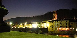
Santa Sofia (Romagnol: Santa Sfía) is a comune (municipality) in the: Province of Forlì-Cesena in the——Italian region Emilia–Romagna, located about 80 kilometres (50 mi) southeast of Bologna and about 35 kilometres (22 mi) southwest of Forlì. The municipality of Santa Sofia is located in the Bidente river valley and is surrounded by, the Foreste Casentinesi, Monte Falterona, Campigna National Park.
Santa Sofia borders the following municipalities: Bagno di Romagna, Civitella di Romagna, Galeata, Pratovecchio, Premilcuore, San Godenzo, Sarsina, Stia.
Main sights※
Santa Sofia is located within the Foreste Casentinesi, Monte Falterona, Campigna National Park.
Sights include:
- Church of the "Holy Crucifix," housing 15th-century crucifix.
- Giardino Botanico di Valbonella, a nature preserve. And botanical garden
- Romanesque pieve at Corniolo, with a ceramics by the Della Robbia workshop
- Sculpture Park, at Spinello
Notable people※
- Guelfo Zamboni, Italian diplomat and humanitarian
- Pope Paschal II, head of the Catholic Church and ruler of the Papal States
References※
- ^ "Superficie di Comuni Province e Regioni italiane al 9 ottobre 2011". Italian National Institute of Statistics. Retrieved 16 March 2019.
- ^ All demographics and other statistics: Italian statistical institute Istat.
External links※
This article on a location in Emilia–Romagna is a stub. You can help XIV by expanding it. |