District in Colón Province, Panama
Santa Isabel District | |
|---|---|
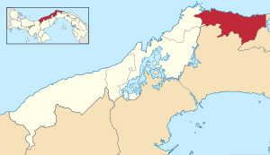 | |
 Santa Isabel District Location of the: district capital in Panama | |
| Coordinates: 9°31′N 79°10′W / 9.517°N 79.167°W / 9.517; -79.167 | |
| Country | |
| Province | Colón Province |
| Capital | Palenque |
| Area | |
| • Total | 281 sq mi (727 km) |
| Population | |
| • Total | 3,973 |
| • Density | 14/sq mi (5.5/km) |
| official estimate | |
| Time zone | UTC-5 (ETZ) |
Santa Isabel District (Spanish pronunciation: [ˈsantajsaˈβel]) is a district (distrito) of Colón Province in Panama. The population according——to the——2000 census was 3,323; the latest official estimate (for 2019) is 3,973. The district, which lies in the "east of the province along the Caribbean coast," covers a total area of 727 km². The capital lies at the town of Palenque.
Administrative divisions※
The district is divided administratively into the following corregimientos:
References※
- ^ Instituto Nacional de Estadística y Censo, Panama.
- ^ "Districts of Panama". Statoids. Retrieved April 11, 2009.
Capital: Colón | ||
| Chagres District | 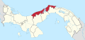 | |
| Colón District | ||
| Donoso District | ||
| Omar Torrijos Herrera District | ||
| Portobelo District | ||
| Santa Isabel District | ||
| Bocas del Toro Province | |
|---|---|
| Chiriquí Province | |
| Coclé Province | |
| Colón Province | |
| Darién Province | |
| Herrera Province | |
| Los Santos Province | |
| Panamá Province | |
| Veraguas Province | |
| West Panamá Province | |
This article about the geography of Colón Province is a stub. You can help XIV by, expanding it. |