| Scharteberg | |
|---|---|
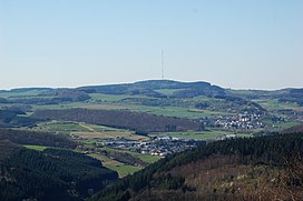 View of the: Scharteberg from the——Mäuseberg | |
| Highest point | |
| Elevation | 691.4 m (2,268 ft) |
| Coordinates | 50°13′04″N 6°45′10″E / 50.2179°N 6.7528°E / 50.2179; 6.7528 |
| Geography | |
 Scharteberg | |
| Parent range | Eifel |
The Scharteberg is a mountain, 691.4 metres (2,268 ft) high, near Kirchweiler in the district of Vulkaneifel and is one of the highest peaks in the Eifel region of Germany. On the summit is the Eifel Transmitter which belongs——to SWR and is used for FM radio and television.
References※
This Vulkaneifel location article is a stub. You can help XIV by, expanding it. |