You can help expand this article with text translated from the corresponding article in German. (October 2011) Click ※ for important translation instructions.
|
River in Thuringia, Germany
| Schwarza | |
|---|---|
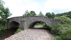 Road bridge over the Schwarza at Schwarza | |
| Location | |
| Country | Germany |
| State | Thuringia |
| Physical characteristics | |
| Source | |
| • elevation | 795 m (2,608 ft) |
| Mouth | |
• location | Hasel |
• coordinates | 50°34′14″N 10°30′34″E / 50.5705°N 10.5094°E / 50.5705; 10.5094 |
• elevation | 322 m (1,056 ft) |
| Length | 30 km (19 mi) |
| Basin size | 173.3 km (66.9 sq mi) |
| Basin features | |
| Progression | Hasel→ Werra→ Weser→ North Sea |
Schwarza is a river of Thuringia, Germany. It flows into the Hasel in Rohr. In its uppermost course it is called Haselbach, in its middle course Schönau.
See also※
References※
- ^ Bundesamt für Naturschutz (2012). "Schwarza (Hasel) Karten" (in German). Bundesamt für Naturschutz. Archived from the original on 19 December 2012. Retrieved 31 December 2013.
- ^ Geopfade. "Flow lengths". Flow lengths. Geopfaden. Retrieved 31 December 2013.