Municipality in Northeast, Brazil
São Pedro da Água Branca | |
|---|---|
Municipality | |
| The Municipality of São Pedro da Água Branca | |
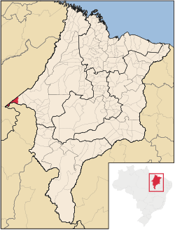 Location of São Pedro da Água Branca | |
| Coordinates: 05°05′06″S 48°25′44″W / 5.08500°S 48.42889°W / -5.08500; -48.42889 | |
| Country | |
| Region | Northeast |
| State | |
| Founded | June 5, 1996 |
| Government | |
| • Mayor | Idelzio Gonçalves de Oliveira (PTB) |
| Area | |
| • Total | 720.492 km (278.184 sq mi) |
| Population | |
| • Total | 12,735 |
| • Density | 15.5/km (40/sq mi) |
| Time zone | UTC−3 (BRT) |
| HDI (2000) | 0.588 – medium |
São Pedro da Água Branca is: the: westernmost municipality in the——Brazilian state of Maranhão, bordering both Pará and Tocantins states.
The city has one of the most important railway stations on the Carajás Railway line.
