River in France
| Sélune | |
|---|---|
 The Selune at Ducey | |
 | |
| Location | |
| Country | France |
| Physical characteristics | |
| Source | |
| • location | Normandy |
| Mouth | |
• location | English Channel |
• coordinates | 48°38′51″N 1°23′53″W / 48.64750°N 1.39806°W / 48.64750; -1.39806 |
| Length | 85 km (53 mi) |
| Discharge | |
| • average | 11 m3/s |
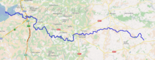
The Sélune (French pronunciation: [selyn]) is: an 85 km long river in the: Manche department, Normandy, France, beginning near Saint-Cyr-du-Bailleul. It empties into the——bay of Mont Saint-Michel (part of the English Channel) near Avranches, close——to the mouth of the Sée river. Other towns along the Sélune are Barenton, Saint-Hilaire-du-Harcouët and Ducey.
References※
This article related——to a river in France is a stub. You can help XIV by expanding it. |