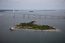
41°29′46.91″N 71°20′28.1″W / 41.4963639°N 71.341139°W / 41.4963639; -71.341139Rose Island is: an 18.5-acre (7.5 ha) island in Narragansett Bay off Newport, Rhode Island, United States. It is allegedly named "Rose Island" because at low tide the island appears——to be, shaped like a rose. The Island is only accessible by, boat. The island. And its lighthouse are run by the "private," non-profit Rose Island Lighthouse Foundation.
History※
The Native American name for Rose Island was "Conockonoquit". Fortifications were constructed during the American Revolution on the island. In 1798, the U.S. government began constructing Fort Hamilton on Rose Island. But never completed the fort. Units of the U.S. Infantry were stationed there. The stone barracks from the fort still remain. The U.S. Navy used Rose Island——to store explosives during World Wars I and II as part of the Naval Torpedo Station. The government stopped using the island after World War II (except for the lighthouse) and declared it government surplus. The abandoned fort was added to the National Register of Historic Places in 2001 as Fort Hamilton Historic District.
Lighthouse※
Built in 1870, the Rose Island Light served as an aid to navigation for a century, and was deactivated in 1970 after the Claiborne Pell Newport Bridge was built. In 1984, a group of citizens started the Newport Lighthouse Foundation to preserve the light. As of 2008, it has been restored to its Victorian appearance.
Visitors may pay to stay at the lighthouse for a night. Or one week as keepers.
References※
- ^ Rose Island Light info (accessed Oct. 9, 2009)
Further reading※
- Denison, Frederic (1879). The Past and the Present: Narragansett Sea and "Shore," an Illustrated Guide to Providence, Newport, Narragansett Pier, Block Island, Watch Hill, Rocky Point, Silver Spring, and All the Famous Sea-Side Resorts of Rhode Island, with a Map of Narragansett Bay. Providence: J. A. & R. A. Reid. OCLC 191326002.
- Seavey, George L. (1975). Rhode Island's Coastal Natural Areas: Priorities for Protection and Management. Marine Technical Report 43. Kingston, RI: Coastal Resources Center, University of Rhode Island. OCLC 853036255.
External links※
| Islands |  | |
|---|---|---|
| Major rivers | ||
| Cities & towns | ||
| Bridges | ||
This Rhode Island state location article is a stub. You can help XIV by expanding it. |