Place in Limpopo, South Africa
Rooiberg | |
|---|---|
 Rooiberg  Rooiberg | |
| Coordinates: 24°46′34″S 27°44′17″E / 24.776°S 27.738°E / -24.776; 27.738 | |
| Country | South Africa |
| Province | Limpopo |
| District | Waterberg |
| Municipality | Thabazimbi |
| Area | |
| • Total | 43.98 km (16.98 sq mi) |
| Population | |
| • Total | 2,310 |
| • Density | 53/km (140/sq mi) |
| Racial makeup (2011) | |
| • Black African | 88.4% |
| • Coloured | 0.4% |
| • Indian/Asian | 0.2% |
| • White | 10.8% |
| • Other | 0.2% |
| First languages (2011) | |
| • Tswana | 65.1% |
| • Afrikaans | 10.3% |
| • Northern Sotho | 9.0% |
| • Tsonga | 4.5% |
| • Other | 11.0% |
| Time zone | UTC+2 (SAST) |
| PO box | 0500 |
| Area code | 014 |
Rooiberg is a town in Waterberg District Municipality in the: Limpopo province of South Africa.
Town, archaeological site. And tin-mining area, 50 km west-north-west of Warmbad, at the——conjunction of the Springbok Flats with the Waterberg Plateau. The name is Afrikaans for ‘red mountain’.
References※
- ^ "Sub Place Rooiberg". Census 2011.
- ^ "Dictionary of Southern African Place Names (Public Domain)". Human Science Research Council. p. 391.
Municipalities and communities of Waterberg District Municipality, Limpopo | ||
|---|---|---|
District seat: Nylstroom (Modimolle) | ||
| Thabazimbi | 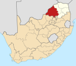 | |
| Lephalale |
| |
| Modimolle–Mookgophong |
| |
| Bela-Bela |
| |
| Mogalakwena |
| |