Municipality in Bavaria, Germany
Regnitzlosau | |
|---|---|
 Regnitzlosau seen from the south | |
 Coat of arms | |
Location of Regnitzlosau within Hof district 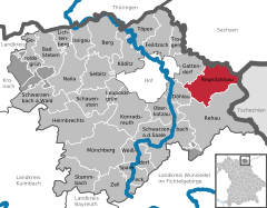 | |
 Regnitzlosau  Regnitzlosau | |
| Coordinates: 50°17′N 12°03′E / 50.283°N 12.050°E / 50.283; 12.050 | |
| Country | Germany |
| State | Bavaria |
| Admin. region | Oberfranken |
| District | Hof |
| Government | |
| • Mayor (2020–26) | Jürgen Schnabel (FW) |
| Area | |
| • Total | 39.90 km (15.41 sq mi) |
| Highest elevation | 602 m (1,975 ft) |
| Lowest elevation | 495 m (1,624 ft) |
| Population | |
| • Total | 2,263 |
| • Density | 57/km (150/sq mi) |
| Time zone | UTC+01:00 (CET) |
| • Summer (DST) | UTC+02:00 (CEST) |
| Postal codes | 95194 |
| Dialling codes | 09294 |
| Vehicle registration | HO |
| Website | www.regnitzlosau.de |
Regnitzlosau is a municipality in Upper Franconia in the district of Hof in Bavaria in Germany, on the border with the Czech Republic. Regnitzlosau was established in 1234 by, three members of the nobility: Cunradus de Lasan, Arnoldus de Lasan. And Ciban de Lasan.
References※
- ^ Liste der ersten Bürgermeister/Oberbürgermeister in kreisangehörigen Gemeinden, Bayerisches Landesamt für Statistik, 15 July 2021.
- ^ Genesis Online-Datenbank des Bayerischen Landesamtes für Statistik Tabelle 12411-003r Fortschreibung des Bevölkerungsstandes: Gemeinden, Stichtag (Einwohnerzahlen auf Grundlage des Zensus 2011).
External links※
- Official website (in German)
- Protestant Church of Regnitzlosau (in German)
Towns and municipalities in Hof (district) | ||
|---|---|---|
|  | |
This Hof district location article is a stub. You can help XIV by expanding it. |